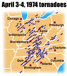
Most tornadoes are found in the Great Plains of the central United States – an ideal environment for the formation of severe thunderstorms. In this area, known as Tornado Alley, storms are caused when dry cold air moving south from Canada meets warm moist air traveling north from the Gulf of Mexico. Tornadoes can form at any time of year, but most occur in the spring and summer months along with thunderstorms. May and June are usually the peak months for tornadoes.


USA map showing the average number of tornadoes per year per 10,000 square miles ranging from fewer  than one in the western and northeastern portions of the USA to pockets of nine in south central USA.

Which two states have the highest number of tornadoes per year per 10,000 sq miles? Choose one of the answers below:


Notice that the location with the highest number of thunderstorms does not match the location with the highest number of tornadoes. Maps showing the average number of thunderstorms days per year on the left and average number of tornadoes per year on the right.  The majority of thunderstorms occur in the south eastern usa while the majority of tornadoes occur in south central usa.

Why do so many tornadoes form in this part of south central North America? Choose one of the answers below:


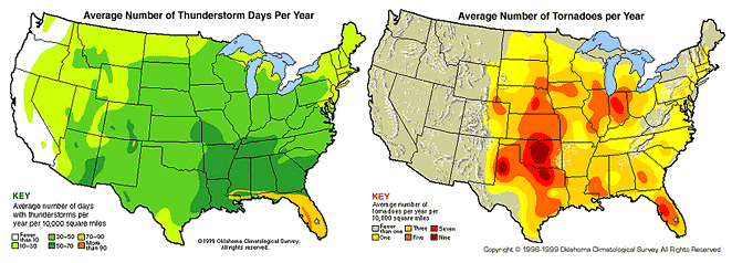
The Great Plains are conducive to the type of thunderstorms (supercells) that spawn tornadoes. It is in this region that cool, dry air in the upper levels of the atmosphere caps warm, humid surface air. This situation leads to a very unstable atmosphere and the development of severe thunderstorms.

April 3-4, 1974 tornadoes.  This map shows a series of blue lines from the midwest to the eastern USA moving from southwest to northeast.

Look at the map above. The blue lines show the paths of tornadoes produced by storms on April 3rd & 4th, 1974. Why are the lines all parallel and pointing in a southwest to north direction?