A Focus on Estuaries
Jump to background information
![]()
This is Part 2 of Lesson 2 of Project Resilience curriculum. Students learn about the vital role estuaries play in coastal environments and build a model to represent the estuary services provided by these unique areas.
Learning Objectives
- Students learn what an estuary is.
- Students create a model to explore the important ecosystem services provided by an estuary.
- Students create an articulate metaphor to explain their model.
Materials
- Project Resilience Slide Deck (slides 12-18)
- Projector & Computer
- Estuary Model Metaphor- Student Sheet(PDF)
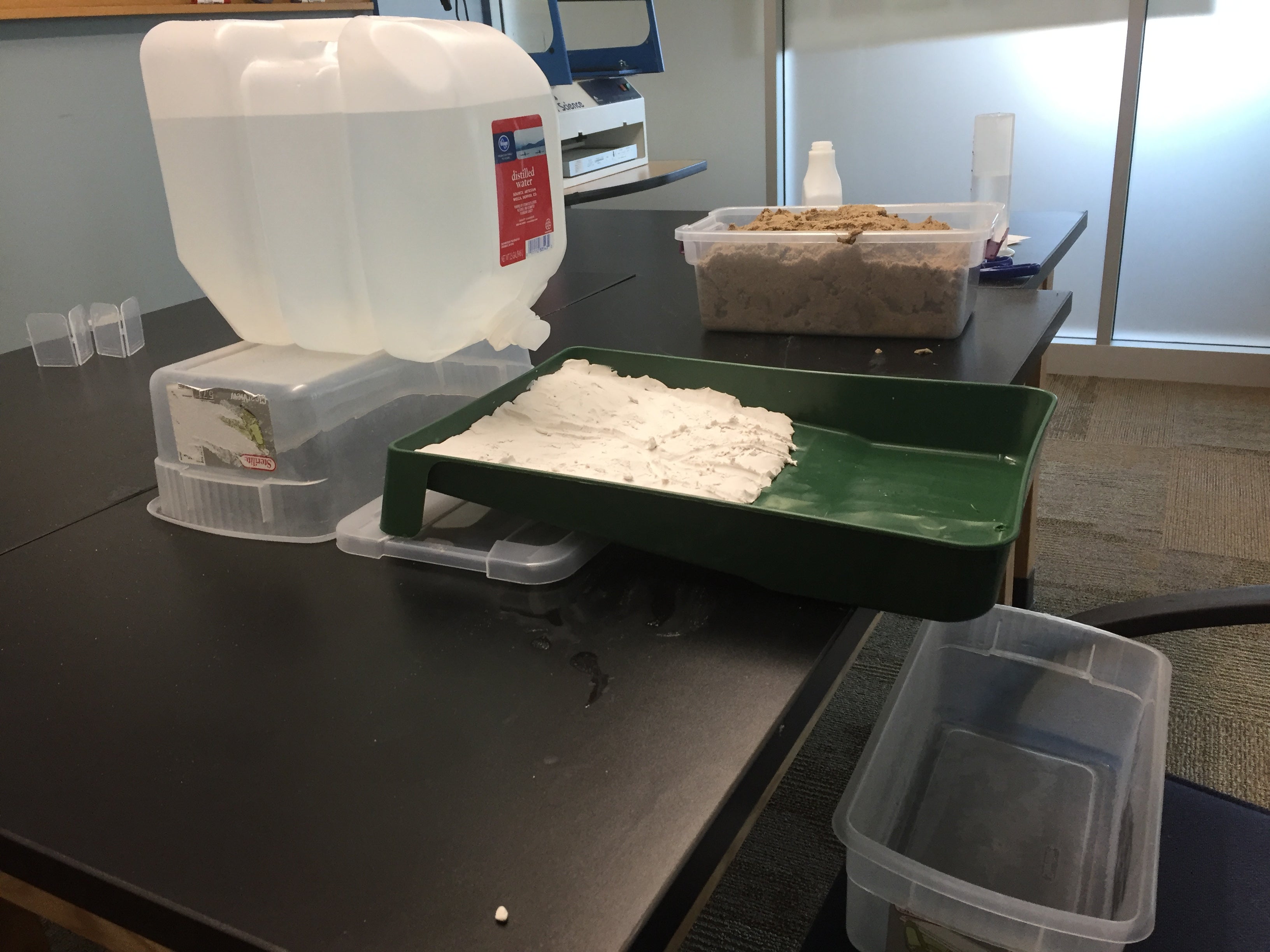
- Paint tray or large baking/roasting pan with a hole at one end for water drainage (one per group)
- Large water container with a spigot (one per group)
- Access to a sink or water source
- Bucket or tub to collect water drainage
- Books, box, or extra tubs to prop up the water containers
- Graduated cylinders (100mL or larger) or liquid cup measurers
- Spray bottles
- Modeling clay (about 5 lbs of clay for every three groups, for Parts 2-3)
- Soil (optional, could use sand from Part 1
- Clay tools, pencil, chopstick, or paintbrush to create features in the clay
- Indoor/outdoor carpeting (strips approximately 3” wide that fit in the paint tray)
- Kitchen sponges
- Food coloring
- Scissors
- Timer
Preparation
- Print copies of the Estuary Model Metaphor Student Sheet (one per group)
- Prepare the classroom for the stream table/modeling activity.
- Organize the wetlands model building materials on a table and assign students to model building groups.
- View the Estuaries: Nature’s Water Filters animation in advance to ensure it works with your technology set up.
Note: Students will use clay in the paint trays during Part 2.
Directions
Introduction to the local estuary (10 minutes)
- Transition from the day before. Tell students today we will build upon our understanding of how the river creates land, but now we will focus on the unique types of land that form where rivers join the ocean.
-
Introduce the definition of an estuary (slide 13):
"Estuaries are bodies of water and their surrounding coastal habitats, typically found where rivers meet the sea. Estuaries harbor unique plant and animal life because their waters are brackish -- a mixture of fresh water draining from the land and salty seawater." (NOAA)
- Show students an example of what an estuary looks like (slide 14). The example in the slide deck shows the area where the Mississippi River meets the Gulf of Mexico in southern Louisiana.
- Introduce the term wetlands, which describes ecosystems with unique types of vegetation adapted to live in water (often with changing water and salinity levels). Wetlands are a feature of estuaries that often develop along the coastline, forming a transition zone between land and sea.
- Point out the wetlands areas in the estuary image from the previous step (in slides).
- Tell students that the land they live on is part of an estuary called the Barataria-Terrebonne National Estuary System (BTNES). Show them the map of the area included within their coastal estuary (slide 15).
- The northern border of the estuary begins near the city of Morganza, LA (not shown on the map, but this might serve as a reference location for Louisiana residents). From there, the estuary includes all of the land between the Atchafalaya and Mississippi Rivers as they flow down to the Gulf of Mexico.
Building an estuary (30 minutes)
- Transition to the stream tables. Tell students their objective is to learn why estuaries are important.
- Break students into small groups (four or five students, depending on class size and materials available) and give each group a stream table tray and a large amount of modeling clay.
- Tell them that their task is to build a model of an estuary, adding wetlands to the coast of their stream tables, and then use the materials provided to model how the presence or absence of an estuary affects the land, water, and the plants and animals that live there.
- Guide students as they add clay to the stream table to build the land and the river.
- To begin, spread a layer of modeling clay in half of the tray to represent land. Leave the other half empty to represent a body of water. Be sure to leave the end with the drainage hole uncovered (this will be the "ocean" side of the tray)
- Shape the clay so that it gradually slopes down to the water. Smooth the clay along the sides of the tray to seal the edges.
- Use clay tools, a pencil, the opposite end of a paintbrush, etc. to form a meandering river with tributaries in the clay that lead to the body of water. Note: Natural levees will often form when the river is carved in the model. If so, have students smooth them down so that it will be easier to model flooding with their model.
- The land should also slope towards the river so that when water is added, some of it will run into the river channel.
- Projecting a map image of the Mississippi River might also be helpful for students to visualize the pattern.
-
Orient students to the materials they can use to model different conditions. All materials should be laid out on a table or counter for students to access. They will decide as a group which materials to use to create various conditions with their model. Students will need to brainstorm ideas and try them out.
Note: students may enjoy recording a time-lapse video of their model, or taking photos.
- Students will build a model that answers these questions (slide 16):
- How does the presence/absence of wetlands affect the amount of water that flows out into the ocean?
- How does the presence/absence of wetlands affect the amount of sediment that flows out into the ocean?
- How do rainfall events of differing intensity affect the environment (average rainfall, heavy rainfall, flooding) with and without wetlands?
- How does the presence/absence of wetlands affect the number of pollutants that flow out into the ocean?
- Review the facilitation tips listed in the Inquiry Activity: Modeling an Estuary in the box below as needed to provide guidance during the modeling activity.
Inquiry Activity: Modeling an Estuary
Facilitation Tips:
Note: Use the same basic setup from the How a Delta Forms activity (Lesson 2: Part 2), only this time use clay instead of sand.
-
Groups should all start with the same basic setup, as shown in the picture on the right. Prop the top of the tray up to increase the slope.
-
Students can create the main channel of the river and some tributaries by carving out clay with a clay tool or the end of a paintbrush/pencil. Point out that they should be careful not to create natural levees as they carve the river because this will prevent water and sediment from entering the river channel.
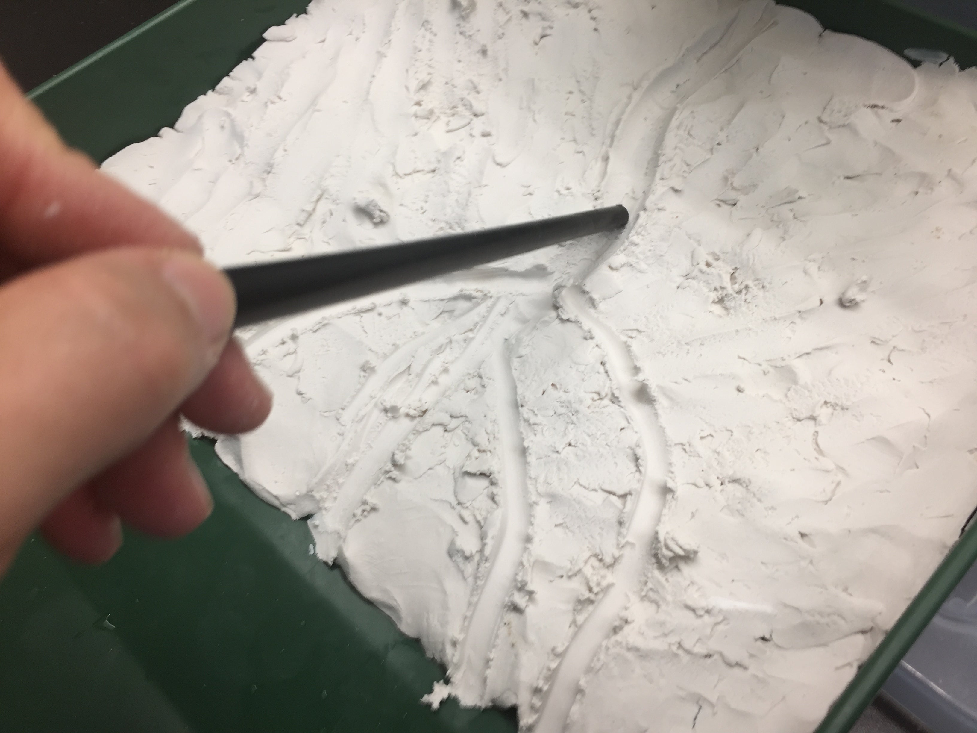
To avoid this, press down on the clay so that the river banks are level with the ground.
- Ask students to brainstorm how they will add water to their system before they get started. How will they represent a typical rainfall vs. a heavy rainfall vs. a flood? How will they determine if adding wetlands to their model has an impact on the amount of water that flows into the ocean?
- Students may want to write out a brief outline of steps as they plan to create different situations.
-
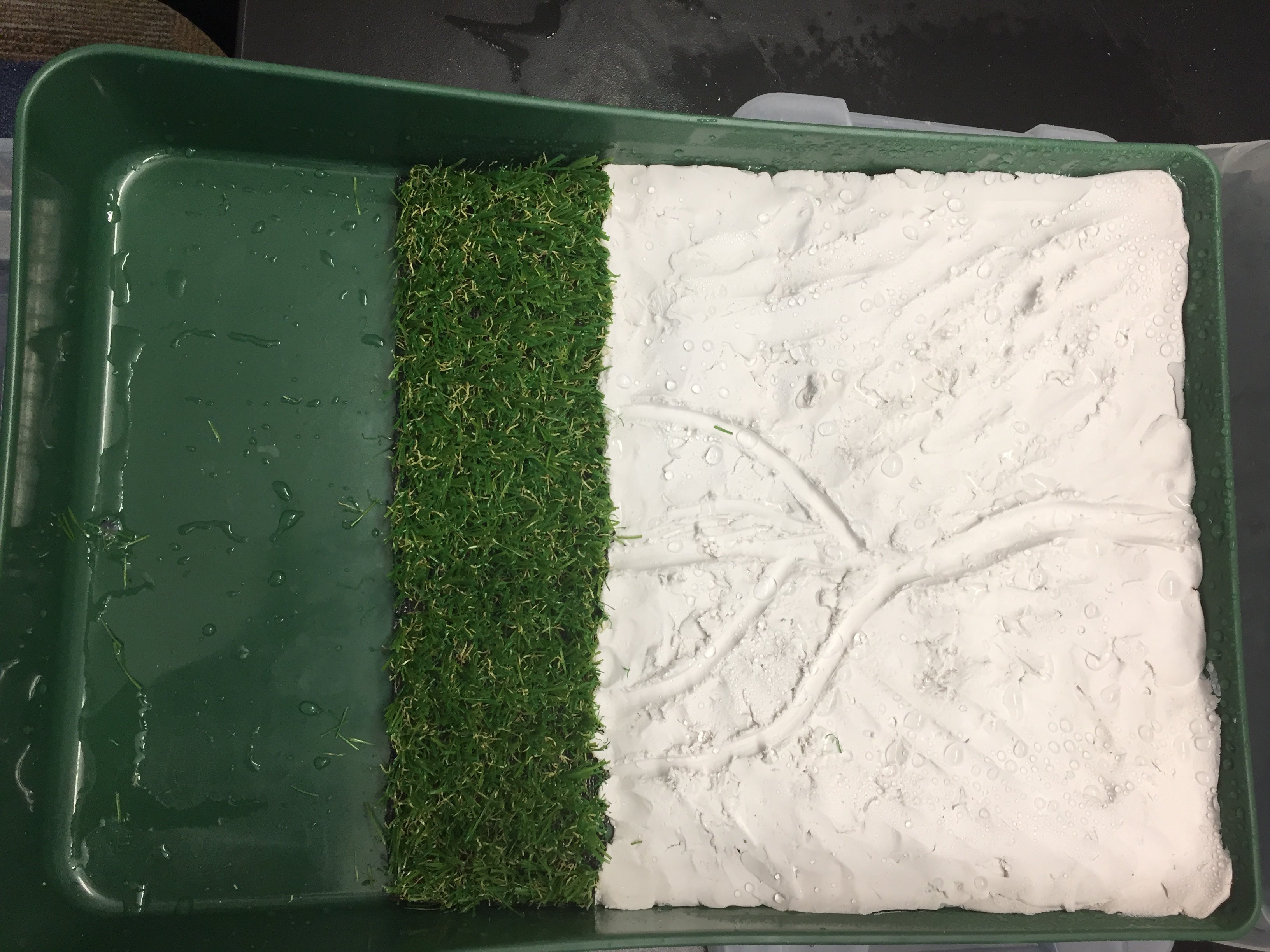
Point out that they will likely be taking their “wetlands” in and out of the model. They want their carpet/sponge to fit snugly against the clay “coastline” without any gaps, as shown, but they should be able to remove it as needed. Note: the “wetlands” should not extend all the way to the end of the tray. Be sure students leave open space for their “ocean” to form, as shown in the photo on the right, so that they can observe the water being filtered by the estuary.
-
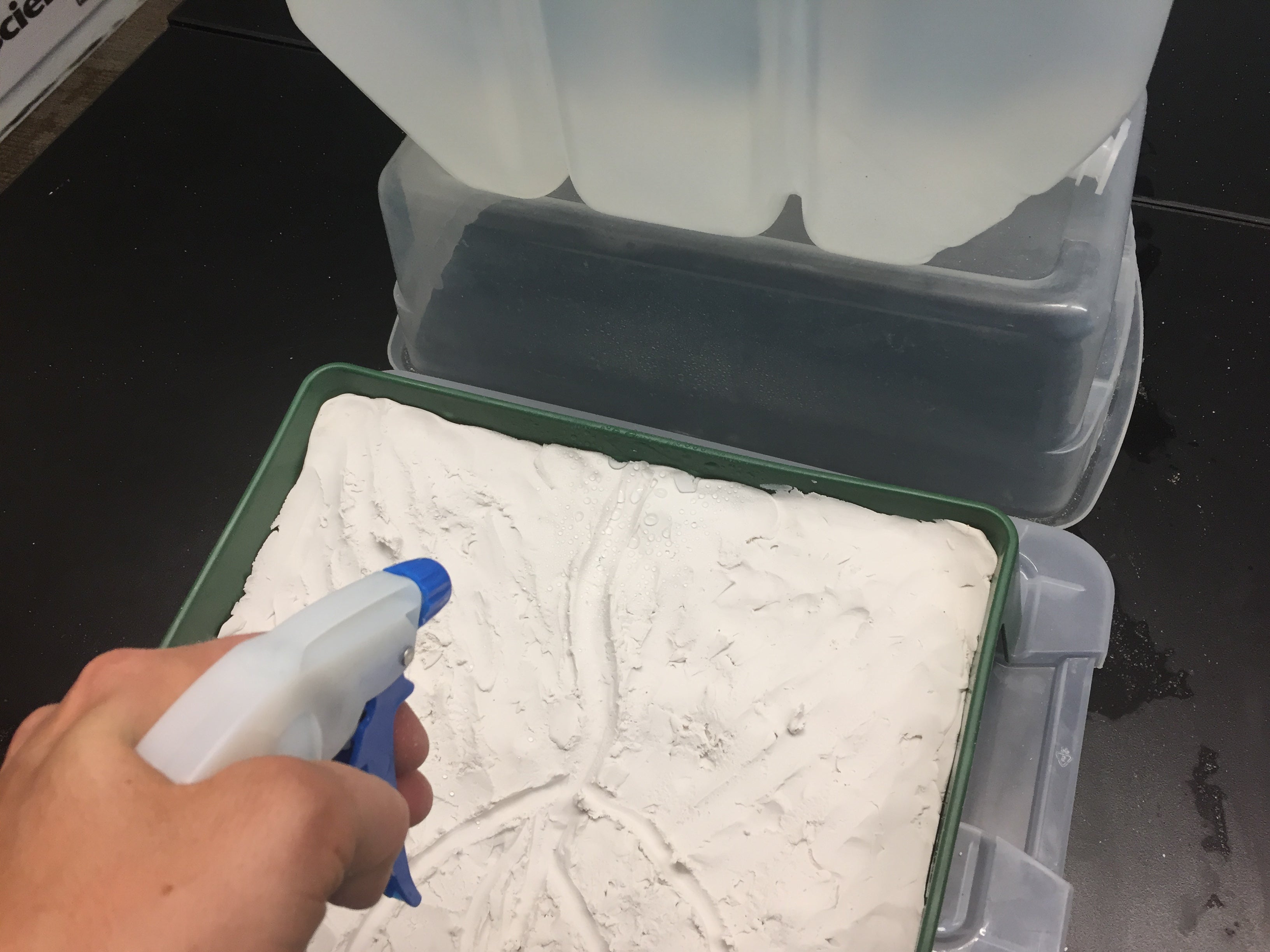
When adding water to their system, students will want to consider how to model different amounts of rainfall. Using a spray bottle could replicate rain (either normal rain or heavy rain, depending on how quickly you spray the water). Pouring water with a cup or opening the spigot as much as possible could replicate a severe weather event. Students should test their model to see if the rainwater will run into their river. If not, sculpt the clay so that it slopes towards the river.
-
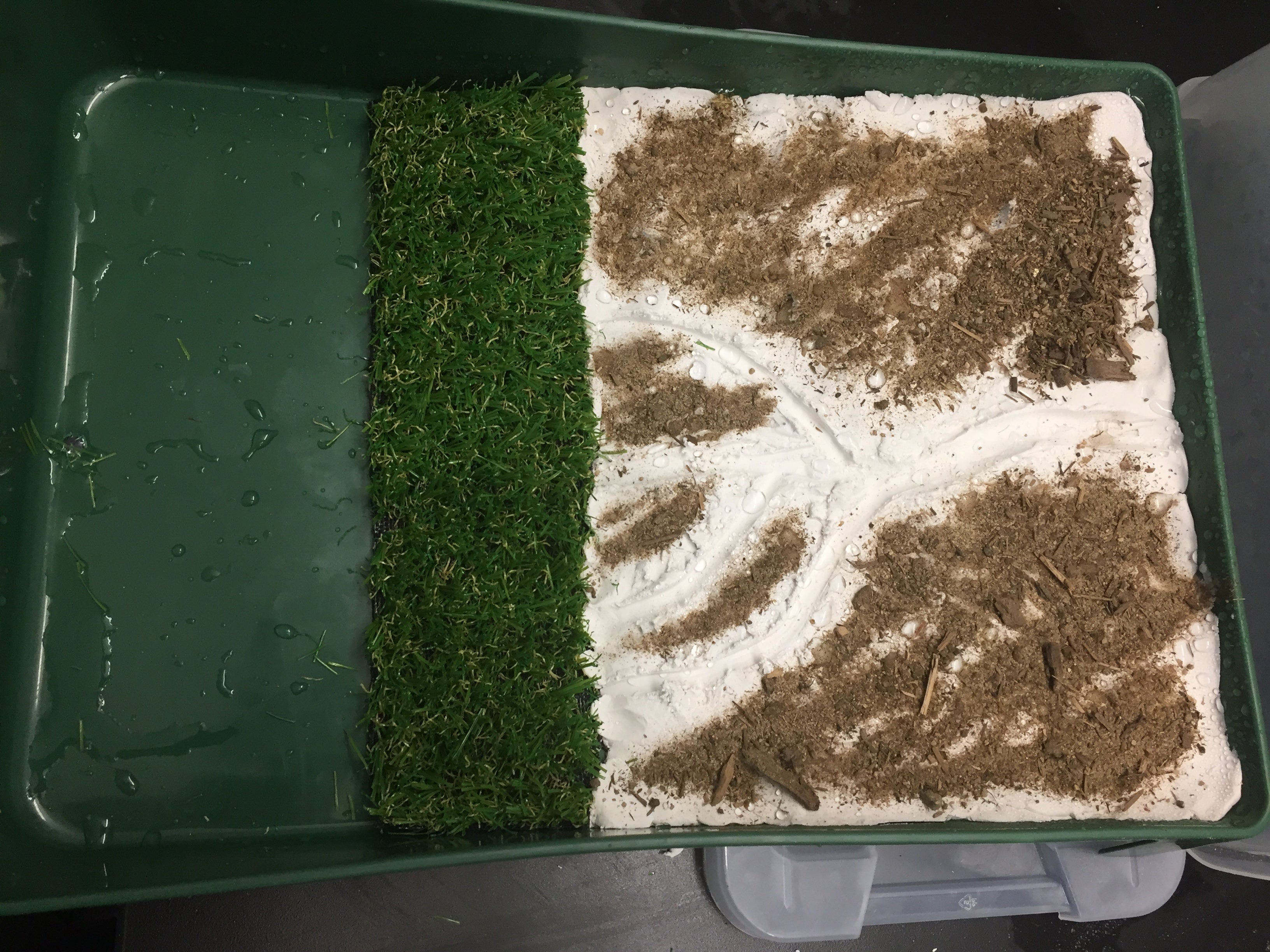
When adding sediment (soil/sand) to the model, tell students to avoid putting it directly into the river channel (since sediment washes into the river from the land), as shown in the picture. Once the “rain” or “flooding” is added to the model, sediment should wash into the river and down towards the estuary, just as it would in nature.
- Groups can rinse their model between setups if they desire. The clay and features will remain intact.
- The food coloring is suggested as a way to simulate pollutants in the water. Students can decide whether to add the food coloring directly to the river or add it through the spray bottle, or both! Encourage experimentation.
-
Pass out a copy of the Estuary Model Metaphor Student Sheet to each group. Explain that they will use this table to write statements to explain how their model represents the real world. The first line on the table is filled in as an example.
- As students complete their modeling and metaphor tables, encourage them to visit other groups to compare and explain their models to each other.
Note: Models will be used again in the Modeling Hydrologic Modification lesson, do not discard them!
Wrap-up: Discussing the importance of estuaries (10 min)
- Debrief the estuary models as a whole class.
- What happened to the sediment when there wasn’t an estuary present?
- What happened during heavy rain or flood?
- What did your model show about how pollutants move through the system?
- Show the animation Estuaries: Nature’s Water Filters (slide 17). Note: Click through the animation until you reach the “Play the Pollution Game” segment.
- The functions of an estuary are referred to as “ecosystem services,” filtering the water from pollutants and excess nutrients, holding on to sediment, and slowing the flow of water.
- Ask students to relate their models to the function of estuaries shown in the animation.
- Point out that as it rains, many nutrients are carried into the river and end up in the estuaries as well, not just sediment and pollutants. The nutrient-rich marshes and soils that form in estuaries are a habitat for many species of plants and animals.
- To close the day, discuss the estuary that your students live in. In this case, it is the Barataria-Terrebonne Estuarine Basin (slide 18).
- How is the estuary you live in important to you as an individual? How is it important to the community?
- What evidence is there of ecosystem services provided by the Barataria-Terrebonne Estuary?
- What examples of changes to the estuary/wetlands are you aware of? How does this impact our community? (The land along the road headed to Grand Isle is an example of fragmented marshlands. Grand Terre Island is also an example of marshland loss.)
- Consider creating a class list of their ideas and posting it for later reference.
Assign journal prompt #3
- Prompt #3: Think about the ecosystem services that an estuary provides to the environment and describe how the environment you live in could change if the estuary were no longer there. Come up with your own metaphor for what an estuary is like and describe it.
Background Information
The Barataria-Terrebonne Estuarine System
Excerpt below from The Barataria Terrebonne National Estuary
"The Barataria-Terrebonne Estuary System (BTES) is a biologically rich and productive ecosystem encompassing 4.1 million acres of upland forests, swamps, marshes, bayous, bays, and barrier islands, bound on the west by the Atchafalaya River and on the east by the Mississippi River in south Louisiana. Sixteen parishes fall within its boundaries. Those parishes include Ascension, Assumption, Iberville, Jefferson, Lafourche, Plaquemines, Pointe Coupee, St. Charles, St. James, St. John the Baptist, St. Mary, Terrebonne, West Baton Rouge and only small portions of Iberia, St. Martin, and Orleans.
"The BTES produces a half-billion pounds of fish and oysters annually and supplies 10-15% of our nation’s oil production. Its expansive marshes provide habitat for previously endangered species such as the brown pelican and the bald eagle, as well as other waterfowl and migratory birds. Recreational opportunities for residents and visitors from around the world abound. The health of the estuary and the quality of its bayous, bays, fish, and wildlife are critical to our regional economy and the sustenance of our nationally-unique culture.
"The most important factor contributing to land loss in the BTES is subsidence, a complex process in which marsh sediments compact and sink under their own weight. Historically, the annual floods over the banks of the Mississippi River provided fresh water and sediment to BTES marshes, which kept them above water. Levees were constructed to protect communities across the nation from these floods, but they also prevent water and sediment from reaching the BTES marshes.
"Subsidence drowns coastal marshes, causing chemical changes in wetland soils, which eventually kill marsh vegetation. Without plant roots to hold it together, the marsh soil breaks up and is carried away by wave action. The end result is the marsh converted to open water. This additional volume of water causes an increase in the tidal prism, forcing passes to enlarge and reducing the lengths of barrier islands, which protects interior marshes from wave action and hurricanes. Barrier islands are also subsiding, and due to both these stressors, they ultimately disappear without new sediment inputs.
"Other human-caused and natural factors can influence land loss rates in the BTES. For example, canals and raised roadbeds, breached natural ridges, and other hydrologic modifications can interrupt tidal exchange and allow salt water intrusion."
What is an estuary?
Excerpt below from NOAA's Estuaries website
"An estuary is a partially enclosed body of water, and its surrounding coastal habitats, where salt water from the ocean mixes with fresh water from rivers or streams. In fresh water, the concentration of salts, or salinity, is nearly zero. The salinity of water in the ocean averages about 35 parts per thousand (ppt). The mixture of seawater and fresh water in estuaries is called brackish water, and its salinity can range from 0.5 to 35 ppt. The salinity of estuarine water varies from estuary to estuary and can change from one day to the next, depending on the tides, weather, or other factors (Levinton, 1995).
"While strongly affected by tides and tidal cycles, many estuaries are protected from the full force of ocean waves, winds, and storms by reefs, barrier islands, or fingers of land, mud, or sand that surround them. The characteristics of each estuary depend upon the local climate, freshwater input, tidal patterns, and currents. Truly, no two estuaries are the same. Yet, they are typically classified based on two characteristics: their geology and how saltwater and freshwater mix in them.
"However, not all estuaries contain brackish waters. There are a small number of ecosystems classified as freshwater estuaries. These estuaries occur where massive freshwater systems, such as the Great Lakes in the United States, are diluted by river or stream waters draining from adjacent lands."
Video: What’s An Estuary? Now you Know
Why are estuaries important?
Information below from NOAA's Why Are Estuaries Important?
Estuaries are important natural places. They provide goods and services that are economically and ecologically indispensable. Often called nurseries of the sea (USEPA, 1993), estuaries provide vital nesting and feeding habitats for many aquatic plants and animals. Most fish and shellfish eaten in the United States, including salmon, herring, and oysters, complete at least part of their life cycles in estuaries. Estuaries also help to maintain healthy ocean environments. They filter out sediments and pollutants from rivers and streams before they flow into the oceans, providing cleaner waters for marine life. Estuaries and their surrounding wetlands are also buffer zones. They stabilize shorelines and protect coastal areas, inland habitats, and human communities from floods and storm surge from hurricanes. When flooding does occur, estuaries often act like huge sponges, soaking up the excess water. Estuarine habitats also protect streams, river channels, and coastal shores from excessive erosion caused by wind, water, and ice.
Threats to estuaries
Excerpt below from NOAA's Human Disturbances to Estuaries
"Because they are transitional areas between the land and the sea, and between freshwater and saltwater environments, estuaries can be seriously impacted by any number of human, or anthropogenic, activities.
"The greatest threat to estuaries worldwide is, by far, their large-scale conversion by draining, filling, damming, or dredging. These activities result in the immediate destruction and loss of estuarine habitats. Until the last few decades, many estuary habitats in North America were drained and converted into agricultural areas; others were filled to create shipping ports and expand urban areas. In the United States, 38 percent of the wetlands associated with coastal areas have been lost to these types of activities (Good et al., 1998). In some areas, estuarine habitat loss is as high as 60 percent.
"Of the remaining estuaries around the world, many are seriously degraded by pollution. People have historically viewed estuaries and waterways as places to discard the unwanted by-products of civilization. Pollution is probably the most important threat to water quality in estuaries. Poor water quality affects most estuarine organisms, including commercially important fish and shellfish. The pollutants that have the greatest impact on the health of estuaries include toxic substances like chemicals and heavy metals, nutrient pollution (or eutrophication), and pathogens such as bacteria or viruses.
"Another, less widely discussed human-caused disturbance is the introduction of non-native or invasive species into estuarine environments."
Monitoring estuaries
Excerpt below from NOAA's Monitoring Estuaries
"The National Estuarine Research Reserve System (NERRS) is a partnership program between NOAA and U.S. coastal states that protects more than one million acres of estuarine land and water. The health of every reserve is continuously monitored by the NERRS System-wide Monitoring Program or SWMP (pronounced “swamp”). SWMP measures changes in estuarine waters to record how human activities and natural events, including weather, affect coastal habitats."
Part 2 Extensions
-
Use the NOAA Why are Estuaries Important? Ecosystem Services website as a resource for understanding the role of estuaries. Assign students to read the page, and then discuss the following prompts with a partner:
- What ecosystem services are estuaries providing?
- How are estuaries like a sponge?
- Where do the pollutants that estuaries filter come from?
- What role do estuaries play in a flood?
In a whole class discussion, ensure that students understand what is meant by “ecosystem services” and can explain the two ecosystem services described in the reading: water filtration and habitat protection. Brainstorm if there are other “services” estuaries provide.
- Have students view the next segment of the Restoring America’s Deltas video about diversity in marshes (time signature 4:46-10:22).
- Discuss connections between the video and the estuary modeling activity they completed in class.
- Ask students to share any questions that they now have after watching the video. Post questions on a Driving Question Board for the class.

Credits
This activity was developed for Project Resilience, funded by the Gulf Research Program of the National Academies of Sciences, Engineering, and Medicine.