Get the Picture - Clouds and Climate
Students review illustrations, maps, cross-sections, and graphs that tell a piece of the story about the effects of clouds on climate. They answer "True and False" questions about each visual and discuss what they take away from the information.
Learning Objectives
- Students will learn that different cloud types have different effects on temperature, that there is uncertainty about how clouds will affect climate in the future, and that most models indicate that clouds will contribute to warming in the future.
- Students will learn different ways that information and data can be conveyed.
Materials
- Projector and screen in the classroom to review answers and discuss
- Paper and pencil for each student
Preparation
- Make a copy of the Get the Picture: Clouds and Climate Images for each group or share the PDF with students to view on computers or tablets.
Directions
- Tell students that they will be tasked with analyzing information in graphics, graphs, and maps that convey information relating to how clouds affect climate.
- Assign students to groups of 2-4. Allow adequate time for students to review, discuss, and decide whether statements about each visual are true or false. Instruct students to document their answers on paper and to analyze the graphics, graphs, and maps in order (they are numbered and some true-false statements about later images contain information that they will have learned from earlier images in the sequence).
- Note that the format of Image 5 might be challenging for students. They may need some support in order to interpret the meaning of the axis (cooling is on the left and warming is on the right) and the meaning of the bars on either side of the point (which is the amount of uncertainty).
- Review and discuss answers:
- Project each visual at the front of the class for discussion and review once students have completed assessing all true/false statements.
- Students should discuss what is being conveyed in each graph and any questions that they might have about it. Keep the order as it is in the PDF to help students see the visual components in the order that they are in the PDF, which will help build understanding.
- Discuss uncertainty: There is a lot we still don’t know about the impacts of clouds on climate and the impacts of climate change on clouds. When discussing Image 5, note that the bars around each dot communicate that models have a range of results. Future research will hopefully decrease uncertainty and make those bars smaller.
- Ask students to consider if the visual representation is more effective and efficient than words alone? Why or why not? Which graph, if any, warrants further clarification? Ask questions that require students to extend what the graphs convey and make future predictions based on some of the trends shown.
Assessment
Provide students with the following question to help them put the pieces together from the Get the Picture: Clouds and Climate Images.
Have students look at the image of Marine Stratocumulus Clouds. Explain that the image is from the GOES satellite, so the clouds are seen from above. Low clouds like these often form over the ocean off the west coast of South America. Over other subtropical oceans like this one, low clouds are also common.
Have students write an answer to the following question:
- What would happen to the climate if these clouds disappear?
- Instruct students to, in their answer, cite the Image numbers (1-5) that provide evidence to support your conclusion.
Answer: Low clouds have a cooling effect (Image 2) because they reflect solar energy out to space (Image 3), so without them, more energy would make it to the Earth’s surface (Image 4), and this would cause warming (Image 5).
Background
In this activity, students are building an understanding of how clouds affect Earth’s energy budget and climate as they interpret graphics, data, and maps. Below are the main ideas about each graphic with links to more information.
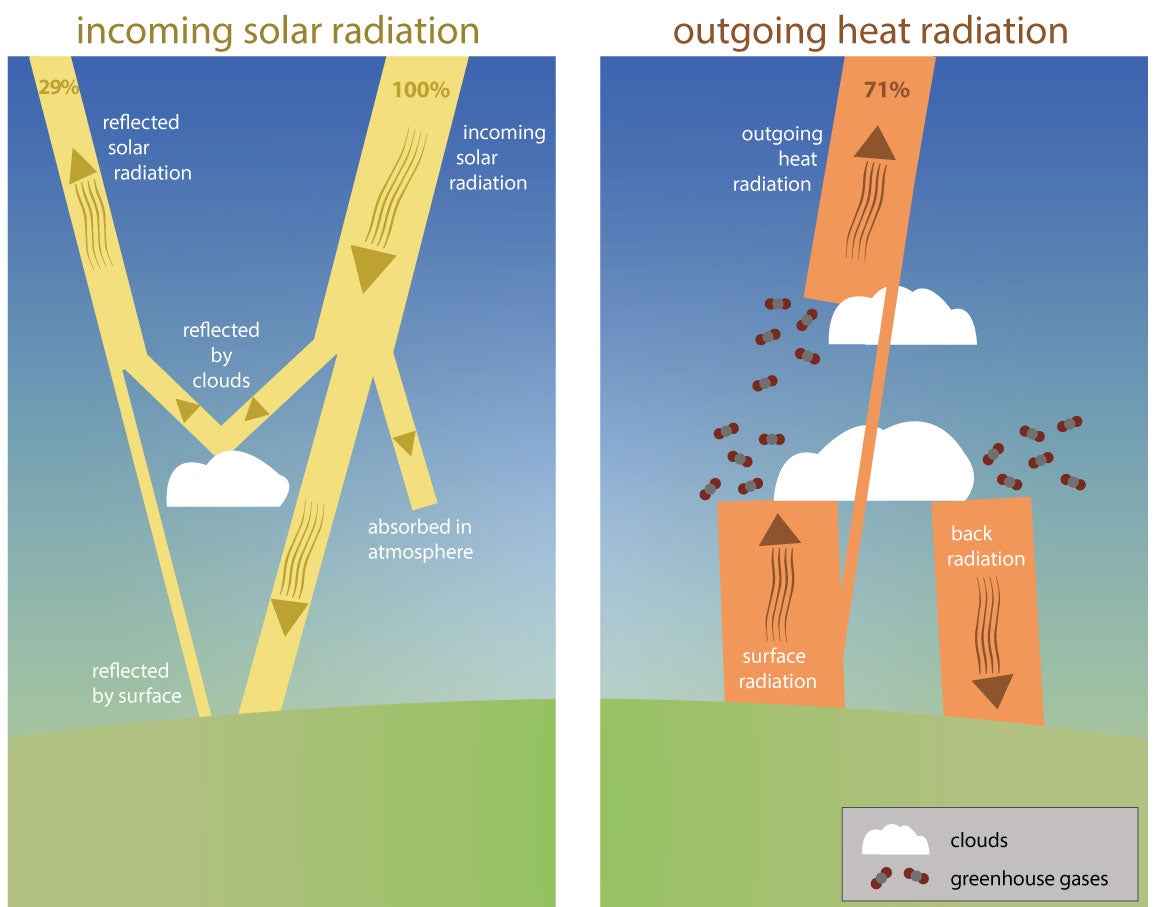 |
Image 1This graphic describes Earth’s energy budget. With a balanced budget, the amount of radiation that gets to Earth from the Sun is equal to the amount of energy that leaves Earth, including reflected solar radiation and energy that is absorbed at the Earth’s surface and then released as heat (infrared). In this graphic, solar radiation is shown in yellow, and heat is shown in orange.
Image 1 Answers:1. F |
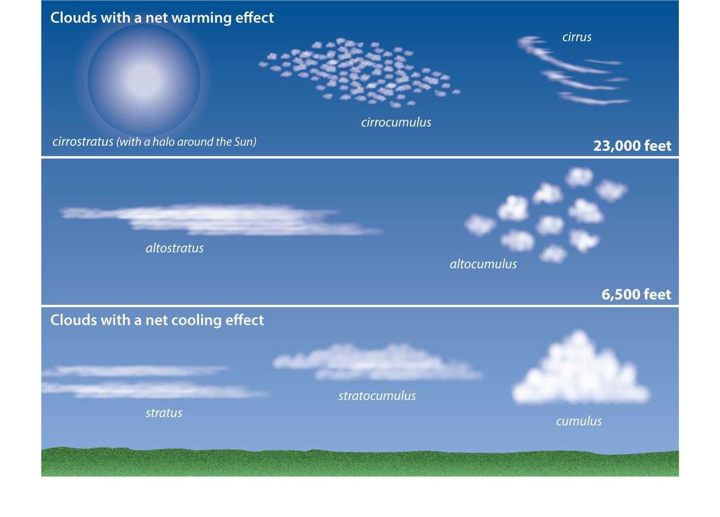 |
Image 2In this graphic, cloud types are shown according to their level within the troposphere, and it’s noted that high clouds (cirrostratus, cirrocumulus, and cirrus) have a warming effect while low clouds (stratus, stratocumulus, and cumulus) have a cooling effect.
Image 2 Answers:1. F |
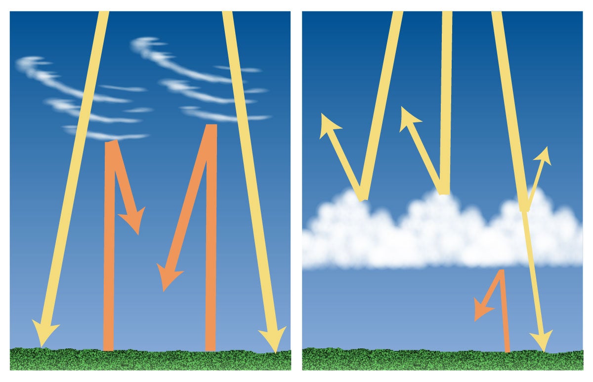 |
Image 3Students consider statements about this graphic and explore why high clouds cause warming, and low clouds cause cooling.
Image 3 Answers:1. F |
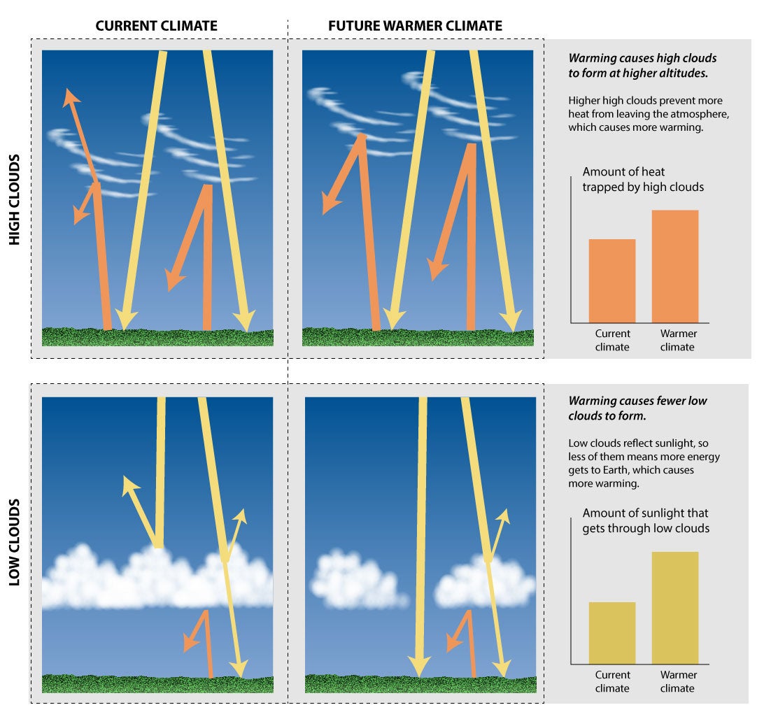 |
Image 4Students build on their learning from Image 3 by comparing the impacts of low and high clouds on the current climate with the impacts in a future warmer climate.
Image 4 Answers:1. T |
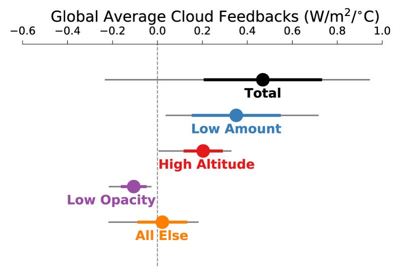 |
Image 5This graph shows the projected impact of clouds on the climate in the future according to the results of 18 climate models. Notice that most clouds, and the total clouds, are on the positive side of the scale. This means that climate models found that clouds will likely have a positive feedback, meaning that they will amplify climate change in the future. For example, if a warming climate causes more clouds that trap heat, this can cause even more warming. Positive, in this case, does not mean “good,” it means that the problem of climate warming is compounded. Because this use of language can be confusing, a positive climate feedback is sometimes called a “vicious cycle.”
Image 5 Answers:1. T |