Sinking Land in the Bayou
![]() This is Part 4 of Lesson 2 of Project Resilience curriculum.
This is Part 4 of Lesson 2 of Project Resilience curriculum.
Students explore how slowing the rate of sediment deposition combined with land subsidence causes land loss in the delta region.
Learning Objectives
- Students will analyze map data to understand that land and marshes are being lost in the Bayou Region and use a model to understand how land and marsh disappear when less sediment is deposited and the land is sinking.
- Students will learn that the loss of wetlands habitat affects species.
Materials
- Project Resilience Slide Deck (slides 29-34)
- Projector & Computer
- Brown Shrimp CER- Student Sheet (PDF)
- Large graduated cylinder or clear tennis ball container
- Two colors of sediment (sand and dirt, for example)
- A meter stick
Preparation
- Print copies of the Brown Shrimp CER- Student Sheet for each student.
- View the video of the sedimentation and subsidence demo to help you prepare to lead this with students. Test out the demo before trying it with students.
- If you are using a clear tennis ball container for the demo, use a permanent marker to label centimeters on the side. If you are using a graduated cylinder, estimate what volume is about a centimeter.
Directions
Analyze maps of land loss (10 minutes)
- Project the 2011 map of the Louisiana coast (slide 30).
- Orient students to the map.
- To help students understand where they are in relation to the 2011 map, project a map of this area using Google Maps.
- Terrebonne Bay is on the left side of the 2011 map. The towns Montegut and Bourg are in the upper left. The larger town in the upper right is Galliano.
- Orient students to the map’s colors: Ask what they think blue represents (water), darker gray (low land or marsh), and lighter gray (higher land). Point out that there are also small amounts of green (and the key at the bottom indicates that this is new land).
- Next, show the 1932 map of the Louisiana coast (slide 31).
- Tell students that this map is of the same area as the previous map.
- Ask students to share what they notice about this 1932 map as compared to the 2011 map.
- Finally, show both maps side by side (slide 32). Hold a class discussion, comparing the two maps and focus on how the coast changed between 1932 and 2011. Use the following prompts during your discussion:
- What is different about the region in 2011 compared to 1932?
- There are more channels through the wetlands, some of the lakes are now open to the ocean, and there is less low-lying land, which is mostly wetland.
- What is the same about the region in both maps?
- The natural bayous are still in the same places, the town of Galliano is in the same place, the barrier islands are still there, etc.
- What type of environment appears to be the most vulnerable?
- The most low-lying land, such as wetlands.
- What is different about the region in 2011 compared to 1932?
Other reasons for land loss: Subsidence demonstration (15 minutes)
- Remind students of our explorations about sediment wasting from the previous day, which is one cause of land loss. Introduce the idea that there is more than one reason for land loss.
- Show the 4 minute Sinking Mississippi Delta video to introduce subsidence (slide 33).
- Have students record observations/interesting ideas and questions in 2 column notes as they watch the video: “What do I notice” in one column, and “What do I wonder?” in the other.
- After watching the video, ensure that there is a common understanding of subsidence (the sinking of land as sediment deposited from the river compacts and sinks down-- this is a natural process!).
- Delta sediment demonstration:
- Draw a cross-section of a wetland on the board with Spartina grasses at the top, sediment and organics in the middle, and a waterline below, but near, the top of the sediment.
- Tell students that this demonstration will simulate how sediment deposition and subsidence happen at the same time in coastal Louisiana. Gather three student helpers.
- One will hold the container.
- One will hold the meter stick.
- One will pour the sand and soil (or you may want to do this yourself).
-
Hold the container so that the bottom of the container lines up with the top of the wetland sediment layer. Hold the meter stick alongside the container.
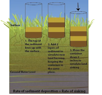
- Tell students that we will first observe what happens when the rate of sediment deposited and the rate of sinking are the same. Demonstrate sediment layers deposited in a container that’s sinking slowly. (see the diagram at the right)
- For the first year: add two centimeters of sediment to the container (deposition) and then lower the container by two centimeters (subsidence).
- Repeat with the other color of sediment for the next year (adding 2 cm of soil to the container, lowering the container 2 cm).
- Alternate the colors of sediment to simulate several years.
- Have students note that the level of the top of the wetlands stays the same.
-
Ask students to predict what will happen if the amount of sediment deposited each year decreases (the land gets lower).
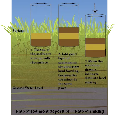
- Test it out: decrease the amount of sediment added for each year, but continue lowering the container by 2 cm. (see the diagram at the right)
- Add one cm of sediment (deposition) to the container and lower it by two cm (subsidence).
- Repeat with the other color of sediment for the next year.
- Alternate the colors of sediment to simulate several years.
- Have students note that the top of the sediment is getting lower over time.
- Figure out how many years it would take to be underwater, given the location of the waterline on the board.
- Ask students to predict what would happen if more sediment was deposited. Students should understand that the land would build higher if the amount of sediment deposited is more than the amount the land is sinking (if time allows, simulate this with students).
- Remind students about their delta/estuary models and the impact of artificial levees on the sediment supply and velocity (from Lesson 2: Part 3) to help them understand why there would be less sediment in the Mississippi delta now than in the past.
Note: there are other factors that contribute to wetlands loss. On a local scale, cutting channels through the wetlands for boats or oil and gas infrastructure causes erosion of the sediments. On a large scale, global sea level rise contributes to wetlands loss, which is covered during the next lesson.
The impact of lost wetlands on brown shrimp (15 minutes)
Note: This activity could be started in class and completed as homework.
- Ask students: How do you think wildlife is affected by wetlands loss? Discuss.
- Present students with the following claim (slide 34): Fewer wetlands in Louisiana means less brown shrimp.
- Pass out copies of the Brown Shrimp CER- Student Sheet. Instruct students to use the information on the student sheet, as well as from their own experiences, as evidence to support the claim. They should also explain their reasoning.
- Note: Students may also wish to explain other factors besides wetlands loss that are making shrimp populations vulnerable, such as pollution.
- Share out some examples of evidence and reasoning once students have had some time to fill out the activity sheet.
- Students should notice that brown shrimp depend on estuaries and marsh wetlands for part of their life cycle.
- Students should notice that Louisiana is experiencing extensive wetlands loss as compared to the other Gulf coastal states (Note: this is because Louisiana is at the center of the Mississippi River drainage basin).
- Students should notice that Louisiana is a major source of brown shrimp in the Gulf.
- By piecing this evidence together, students should make connections between the loss of Louisiana wetlands and the risk to brown shrimp populations.
- Though it is not addressed in this activity, students may also note the potential impact on shrimp fisheries, which are an important part of Louisiana’s economy and culture. This will be covered more extensively in Lesson 3: Part 3.
Transition
- Transition to the next lesson: Tell the students that there is another part of the story. The next lesson will explore how sea level rise caused by climate change is also causing land and marsh to become submerged.
Revisit Driving Question Board (10 min)
- Have students revisit the class Driving Question Board (DQB) that they created in Lesson 1. You might consider doing this in small groups and then share out as a whole class. Ask the following questions:
- Are there any questions that we can now answer?
- Do we want to re-arrange any of the questions? Are there any connections between topics that we should show on the DQB?
- Would anyone like to add any additional questions?
Assign Journal Prompt #5
- Prompt #5: In today’s lesson about land loss, you were asked to consider a claim about how brown shrimp and other wildlife might be affected. Write a headline, similar to what you would see in a newspaper, that describes how you feel or what you think about this. A headline should be brief but also contain carefully selected words that serve to summarize the main idea. Explain your headline.
Background
About Subsidence
Subsidence is sinking land. Land can sink for many reasons - both natural and human-caused. It can sink slowly over thousands of years. Or it can sink more quickly over tens of years.
Several types of natural processes cause slow subsidence over a long time. Land can sink when there is a large weight on it. For example, Antarctica has been pushed downward by the weight of all the ice that is above it. Subsidence can also happen naturally due to plate tectonics where land is stretched apart, forming faults, and when rocks deep underground cool, become more dense, and sink. Subsidence can also happen near the ground surface as sediment compacts or dissolves in the case of limestone.
Subsidence can also be caused by humans, particularly when we remove materials that were once underground. Where groundwater or oil and gas is extracted from below the surface, the land surface can sink. Mining can also cause the land surface to sink.
In coastal Louisiana, subsidence is occurring for several reasons that are both natural and human-caused.
- Sediment compaction
- Oil and gas extraction
- Groundwater extraction
- Plate tectonics (probably - this is an area of active research)
The opposite of subsidence, uplift, happens when land rises higher over time, which can happen because of plate tectonics movements, such as where cliffs meet the sea on the west coast of North America. It can also happen when land that had been under large amounts of glacial ice bounces back once the ice melts and the weight is removed. This is happening to land in Northern Canada that used to be under an ice sheet during the last Ice Age, about 20,000 years ago.
Learn more:
Part 4 Extensions
- Use the list of Endangered Animals and Plants of Louisiana, which is Section 1-Activity 4-page 8 of the Educator's Guide to the Barataria-Terrebonne Estuary, to see the number of species that depend on the wetlands.
- Have students make a claim about the impact on a specific species if their wetland habitat deteriorates.
- Have students research a species from the list to find evidence to support their claim.

Credits
This activity was developed for Project Resilience, funded by the Gulf Research Program of the National Academies of Sciences, Engineering, and Medicine.