A Vulnerable Environment
![]() This is Part 3 of Lesson 2 of Project Resilience curriculum.
This is Part 3 of Lesson 2 of Project Resilience curriculum.
Students explore how hydrologic modification has upset the natural cycle of delta formation along the Louisiana coast.
Learning Objectives
- Students learn about estuary landforms near their communities.
- Students will understand how hydrologic modification of the Mississippi River has impacted the natural cycle of sediment deposition in the delta and create a model to show how river characteristics change as a result of artificial levees.
Materials
- Project Resilience Slide Deck (slides 19-28)
- Projector & Computer
- Student computers/tablets with Google Earth Pro installed. Note: Chromebooks will need to run the online version of Google Earth instead of downloading Google Earth Pro
- Paint tray or large baking/roasting pan with a hole at one end for water drainage (one per group)
- Large water container with a spigot (one per group)
- Access to a sink or water source
- Bucket or tub to collect water drainage
- Books, box, or extra tubs to prop up the water containers
- Graduated cylinders (100mL or larger) or liquid cup measurers
- Spray bottles
- Modeling clay (about 5 lbs of clay for every three groups, for Parts 2-3)
- Soil (optional, could use sand from Part 1
- Clay tools, pencil, chopstick, or paintbrush to create features in the clay
- Scissors
- Timer
Preparation
- Prepare the classroom for the stream table/modeling activity.
- Download the free Google Earth Pro to classroom computers. Orient yourself with the software so you can help students navigate during the lesson.
Note: Students will use the same models (with clay) from Part 2 during Part 3.
Directions
Exploring Estuaries using Google Earth Pro (20 min)
Note: To save time, install Google Earth Pro on computers in advance.
- Transition from the day before. Now that we are aware of how the delta and wetlands form, let’s take a look at our local area and identify some of the unique estuary features near us.
- Assign students to work on computers, using Google Earth Pro to view the Barataria-Terrebonne estuary and explore estuary features near them.
- Orient students to Google Earth Pro, using the tips in the box below.
- Once students are familiar with Google Earth Pro, begin exploring estuaries.
Exploring Estuaries Using Google Earth Pro
Note: Google Earth Pro is not compatible with Chromebooks. For Chromebook, use the online Google Earth version instead.
- Download Google Earth Pro and launch the program.
- Type the location you are interested in into the search field in the upper left hand of the screen. To practice navigating, have your students find their school with Google Earth Pro.
- Hover over the navigation tools along the right side of the screen and then practice selecting them to zoom in/out, to rotate your view (drag the “N” around the circle), or to move locations on the map. You can also double click on the map to zoom in, and click and drag your cursor on the map to move locations.
- There are many options for layers, displayed in the box at the bottom left. Many layers will already be enabled so students can explore which they would like to view. Roads and Terrain are good ones to add in, and under “Ocean” you can select to show Dead Zones, which will be a nice prelude to upcoming lessons (they will display as fish skeletons in locations where hypoxic zones have been reported).
- Once students are comfortable navigating with Google Earth Pro, introduce the following estuary landforms and features using the Estuary Landforms and Features- a Google Earth Scavenger Hunt (slides 20-24). Use Google Earth Pro to find these features in your local area:
- Inlets, bays, and sounds
- Find places where freshwater mixes with saltwater to create brackish water.
- Ask students to think about where the water would be more or less salty, and how this might influence the plants and animals that live there.
- A good example is the Mississippi River Gulf Outlet and the surrounding areas (Fort Proctor, from Lesson 1, can be seen from there too!).
- Salt marsh or tidal flats
- Salt marshes have a high influx of nutrients from rivers and streams and often circulation of water through tidal flows
- Search for “Marsh Island” as an example.
- These areas might be difficult to pinpoint. Please suggest a known marsh area that students should navigate to and examine.
- Mangroves
- Mangroves forests consist of salt tolerant trees that can handle fluctuating water levels.
- Mangroves are found in St. Bernard Parish (though they aren’t distinguishable from marshland in Google Earth).
- Barrier Islands
- Barrier islands are bars of sand that are parallel to the mainland.
- Locate examples of barrier Islands, such as Whiskey Island
- Additional features to explore with Google Earth Pro (as time permits):
- To make a connection to deltaic formation (Part 1), type “Mississippi River delta” into the search field and zoom out to see the birdfoot delta features more clearly.
- Inlets, bays, and sounds
- Take a closer look at human-made channels and canals, which stand out from natural features due to their straight/uniform shapes.
- Search for “Houma Navigational Canal” and zoom in to view.
- Ask students to think about how these channels & canals are impacting the wetlands.
- Use this as a transition to the next activity, modeling hydrologic modification.
Hydrologic Modification (5 minutes)
- Show the schematic of the lower Mississippi River (slide 25), which shows the location of levees along the Mississippi River. Point out the river (blue line) and the levees (red lines).
-
Read aloud the quote about artificial levees:
“Because of flood protection measures demanded by the public and then instituted by Congress following the Great Flood of 1927, in conjunction with those of private landowners and the State of Louisiana prior to the flood, artificial levees now line much of the Mississippi River.”-BTNEP
- Ask students to share their experiences with levees: How have levees impacted your community (positively/negatively)?
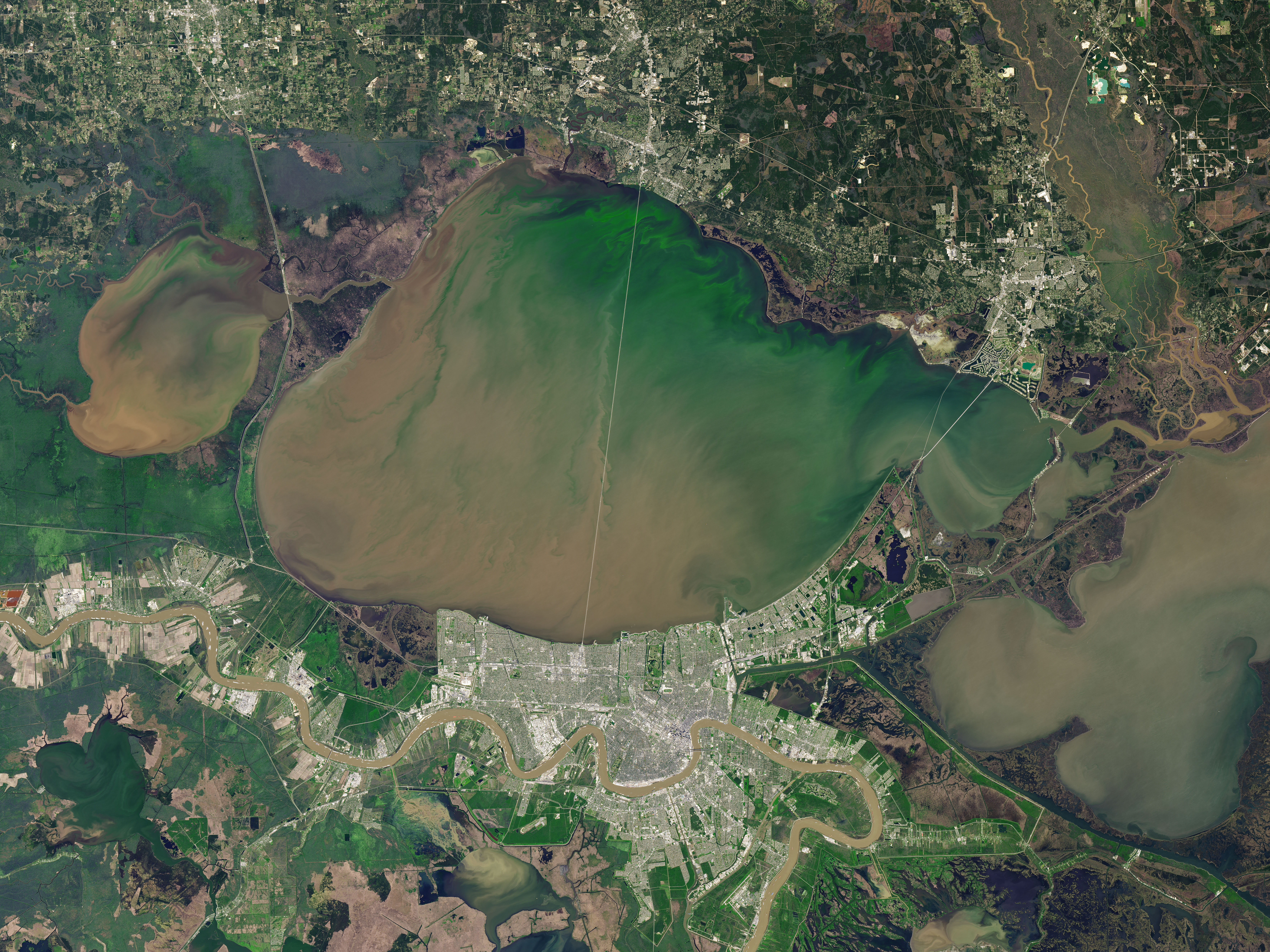
- Show the image of Lake Pontchartrain from March 2018 (slide 26). Ask students to share observations of the image:
- What do you see? What do you notice?
- Explain that the spillway was opened to prevent flooding of New Orleans, diverting fresh water and sediment into the brackish waters of the lake. The spillway has been opened several times since its construction in 1931, including from Feb-July, 2019, when the spillway was opened for the most consecutive days in its history.
- Tell students that these are examples of hydrologic modification, which refers to changing the natural flow of a river. These changes protect communities, but that there are unintended consequences as well.
- Ask students to consider: What could be the impacts of all that water entering Lake Pontchartrain?
- Sediment that should be helping to create land at the delta is going into the lake instead.
- Nutrients entering the lake are causing an overgrowth of algae, which can be toxic and also leads to hypoxia (waters depleted of oxygen, such that aquatic life cannot be supported).
Modeling land loss due to hydrologic modification (20 minutes)
-
Transition to levee modeling activity. Students should return to their model and group from the previous day. If the clay has started to dry and pull away from the sides of the tray, add more clay to seal it. For this modeling activity, remove the wetlands from the model (carpeting/sponge).
Note: students may enjoy recording a time-lapse video of their stream table experiment, or taking photos.
- Pose the question (slide 27): How does hydrologic modification of the river influence the natural cycle of wetland formation in the delta?
- Tell students that their task is to build a model that shows:
- Why flooding is important to the delta. (Where does the sediment end up? )
- What changes occur due to the presence of levees. (What is different? Compare the amount of sediment carried by the river before and after the levees are built.)
- Have students add soil/sand to their model as they did before, sprinkling it over the land. This time it is ok if the soil gets into the river channel.
- Create a flood, by spraying lots of water from the spray bottles or pouring water over the land at the top of their model. Students should notice that the soil is carried down the river and spreads out across the land.
- Where does the sediment end up? What happens when river sediment is spread over the land?
- Reference the video about delta formation from Lesson 2: Part 1 to remind students how seasonal flooding is important in the formation of land at the delta.
- Next, have students use clay to create levees along the entire river. Create rainfall and/or flooding and observe what happens this time.
- Are there any differences? Where does the sediment end up this time? Compare the amount of sediment carried by the river before and after the levees are built.
- Remind students of what changes they saw when the velocity of the water changed in Lesson 2: Part 1. Point out that the levees cause the water to move faster because the channel is narrower, and the water can’t spread out.
- Hold a short discussion to debrief the modeling activity’s key Ideas:
- Flooding and spreading of sediment across the floodplain are unable to happen due to levees.
- Less sediment enters the river due to levees.
- Sediment that does enter the river doesn’t end up where it is supposed to (sediment diversion).
- Limitations of the model
Wrap Up (5 min)
- Exit Ticket: Show the image of sediment wasted (slide 28) and have students write down their answer to the following question as an exit ticket assessment to wrap up the day: How are changes to the Mississippi River causing land loss in coastal Louisiana?
Assign Journal Prompt #4
- Prompt #4: Hydrologic modification is an issue that can be represented as a tug of war. Draw a line across your paper to represent a rope for our ‘hydro’ tug of war scenario. Give a name to each end of the rope that reflects two opposing viewpoints that might be taken in this issue, such as “Hydrologic modification is good because…” on one end, and “Hydrologic modification is bad because…” on the other end. On one side, what are the “tugs” or reasons that support it? You might not personally agree with the tugs, but you can still identify them. On the other side, what are the “tugs” that support it? Write the “tugs” along the rope and consider how the reasons compare with one another. Stronger reasons should be closer to the ends, while reasons that may not be clearly on one side or the other can be closer to the middle.
Background
Hydrologic Modification
Excerpt below from BTNEP: Hydrologic Modification
“Because of flood protection measures demanded by the public and then instituted by Congress following the Great Flood of 1927, in conjunction with those of private landowners and the State of Louisiana prior to the flood, artificial levees now line much of the Mississippi River.
"The levees coincidentally prevent sediment and water from being dispersed into the surrounding wetlands through periodic flooding and levee breaks. Concrete mattresses placed along the channel bank have prevented the natural tendency of the river to change course. In fact, the length of the river has been shortened by approximately 150 miles by cutoffs in the central portion of the lower Mississippi River. Both the shortening of the river and the placement of concrete mats on the banks have reduced the river area exposed to erosion. In the past, soil from the river’s edge was the primary source of sediment that fed the marshes.
"Canals for navigation and oil and gas exploration and production are another type of hydrologic modification. When canals are constructed, the excavated material is placed alongside the canal, creating spoil banks. The impact of this type of activity can be threefold. First, the canal itself creates paths of ingress for waters of higher salinity, forcing animals to either adapt or relocate. Native plants have little choice but to adapt to their new environment or die. Second, erosion can occur along the canal banks with the passing of each vessel, converting more land to open water. Third, the dredged material alters the natural flow of water across the estuary landscape, sometimes creating lakes and, in other cases, depriving large areas of water, nutrients, and sediments.
"Impacts of canals are not, however, all necessarily negative. Canal banks do provide some diversity of habitat, especially in coastal areas. Canals provide significant recreational opportunities and aquatic production potential as well."
Opening the Bonnet Carre Spillway in March 2018 caused algae blooms in Lake Pontchartrain
Excerpt below from NASA Earth Observatory Coloring Lake Pontchartrain
“Blooms of phytoplankton appeared in Lake Pontchartrain several times in March 2018. The Operational Land Imager (OLI) on Landsat 8 acquired this image of a colorful bloom on March 3, 2018.
"Lake Pontchartrain and other nearby lakes and inlets compose a huge estuary east of the Mississippi Delta; collectively, they drain an area spanning 12,000 square kilometers (4,600 square miles). Unusually warm temperatures in February and March helped spur the early spring bloom shown above, even before nutrients from the Upper Mississippi could pour into the region.
"Blooms become more likely when excess river nutrients reach the lake through the Bonnet Carré Spillway. During flood season, the spillway is occasionally opened to divert excess water from the Mississippi River and relieve pressure on levees near New Orleans.
"On March 8, the U.S. Army Corps of Engineers started to open the spillway in response to flooding along the Ohio and Mississippi Rivers. The pulse of sediment-laden water is visible on March 14. Such inputs of nutrients—often fertilizer from the Mississippi watershed—can set the stage for large blooms of algae and cyanobacteria—single-celled organisms that can contaminate drinking water and pose a risk to human and animal health. Satellite imagery can help identify the occurrence of a phytoplankton bloom, but direct sampling is required to discern the species.
"The extra nutrients from the Mississippi helped trigger another bloom around March 25. However, cloud cover impeded satellite views on most days.
"By early April 2018, the blooms appeared less vibrant. John Lopez of the Lake Pontchartrain Basin Foundation reported that wind on the lake helped to break up the second bloom and suppress its growth. But nutrients from the river can persist in the lake for months, making it possible for more blooms to develop later this year.”
Mississippi River Delta basin formation and land loss
Excerpt below from The Mississippi River Delta Basin
“Between 1974 and 1990, the land loss rate in the Mississippi River Delta Basin averaged 1,072 acres per year, or 1.69 percent of existing land area (Dunbar, Britsch, and Kemp 1992). Between the mid-1950s and 1974, the estimated land loss rate for the basin was 2,890 acres per year. This loss is the result of compaction, subsidence, hurricanes, tidal erosion, sea level rise, and human activities. The loss has been aggravated by the maintenance of navigation channels and the construction of canals for mineral exploration. The total land area lost in this basin over the last 60 years has been approximately 113,300 acres.”

Credits
This activity was developed for Project Resilience, funded by the Gulf Research Program of the National Academies of Sciences, Engineering, and Medicine.