Paleoclimates and Pollen
Jump to background information
Students examine "pollen" in simulated lake bottom sediment core samples to infer past climate in the vicinity of the lake.
Learning Goals
- Students will understand that plant pollen is physically distinct in size and shape in different plant species.
- Students will understand that plant pollen may survive for long periods of time in sediment deposits, providing a record of plant species in the area.
- Students will understand that climates naturally undergo changes that can be monitored with pollen data.

Pine, Hemlock and Sweet Gum pollen grains.
Credit: Allen M. Solomon, US EPA
Materials
- A copy of the pollen picture (link displays graphic on its own page for easier printing) for each pair of students. An excellent example of different pollen types is found in the October 1984 issue of National Geographic on pg. 492-493.
- One large graduated cylinder (1000 mL at least) for the "sediment" column. Only one is needed as a demonstration for the class. (If you do not have access to a cylinder, a transparent 2-liter pop bottle could also be used.)
- Five different types of "sediment" if you use the Washington data and six if you use the Colorado data (any soil, sand, potting mixture, etc. that can be layered to show the five or six distinct layers). You will need enough for the sediment column and corresponding "samples."
- One of the following for each pair of students:
- A small, re-sealable plastic bag for the sediment layer sample
- A pie pan for the sediment layer sample
- Sediment/Pollen Sample Preparation Key for your data set
- Tweezers or forceps
- Pollen Key and Data Collection Student Sheet for the data set you've chosen:
- Battle Ground Lake, Washington
- Black Hawk, Colorado
- Eleven (for Washington data) or twelve (for Colorado data) different colors of paper "dots" (from a hole punch) or shaped confetti to serve as pollen analogs
- One permanent marker to label the bags
Preparation Key for Battle Ground Lake, Washington - Pollen/Sediment Samples
Use this table to set up the sediment/pollen sample bags. For example, decide that you will use red beads for pollen type "B" (Douglas fir). Sediment sample bag 1 will include 10 red beads, sediment bag 2 will have 3 red beads, and so on. Sediment bag 1 will also have 6 beads of type "G", 5 of type "A", and 4 of type "D".
The letter codes (letters A through K) for simulated pollen (confetti, beads, etc.) correspond to the letters in Table 1: Pollen Key and Climatic Characteristics of the Vegetation for Battle Ground Lake, Washington on the student page.
You will have to create your own key based on your choice of dot colors or confetti shapes. In the sediment age designations, ybp = years before present. This table is intended for teacher use only. Distributing it to students would give them the answers to the activity.
|
Sediment Layer
|
Plant Species
|
Color or Shape Code
|
Number of dots or confetti needed
|
|
1
(4,500 ybp to present) |
|
|
|
|
2
(4,500 ybp to 9,500 ybp) |
|
|
|
|
3
(9,500 ybp to 11,200 ybp) |
|
|
|
|
4
(11,200 ybp to 15,000 ybp) |
|
|
|
|
5
(15,000 ypb to 20,000 ybp) |
|
|
|
Preparation Key for Black Hawk, Colorado - Pollen/Sediment Samples
The letter codes (letters A through L) for simulated pollen (confetti, beads, etc.) correspond to the letters in Table 2: Pollen Key and Climatic Characteristics of the Vegetation for Black Hawk, Colorado on the student page.
You will have to create your own key based on your choice of dot colors or confetti shapes. In the sediment age designations, ybp = years before present. This table is intended for teacher use only. Distributing it to students would give them the answers to the activity.
|
Sediment Layer
|
Plant Species
|
Color or Shape Code
|
Number of dots or confetti needed
|
|
1
(150 ypb to present) |
|
|
|
|
2
(150 ybp to 650 ybp) |
|
|
|
|
3
(650 ybp to 1,500 ybp) |
|
|
|
|
4
(1,500 ybp to 3,500 ybp) |
|
|
|
|
5
(3,500 ybp to 8,000 ybp) |
|
|
|
|
6
(8,000 ybp to 10,000 ybp) |
|
|
|
Preparation
This activity involves a significant amount of teacher preparation. You may want to enlist several students to help in the preparation and setup. The activity procedural instructions are also included in the Student Guide.
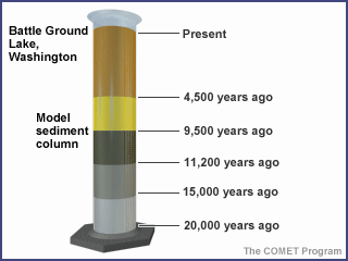
Model sediment column for Battle Ground Lake, Washington site.
Credit: The COMET Program, UCAR
These exercises were developed based on actual pollen data collected from a lake in southwest Washington State and a peat bog in the Rocky Mountains. You can use either or both, just be careful not to confuse the student sheets. Other regions of the country may have similar pollen records available. The botany departments of local universities may be able to provide information on locally relevant pollen data that you can adapt to this exercise.
- Layer five (or six) different kinds of soil (garden soil, sand, fine gravel, potting mixture, peat moss, vermiculite, perlite, or similar material) into the graduated cylinder so they form five (or six) distinct layers. This represents the sediment core with which the students will work. Label the layers with their respective ages as shown. The example shown represents the Battle Ground Lake, Washington sediment core.
- Choose 11 (or 12) different colors of paper or confetti shapes to represent the "pollen" grains. We have suggested colors and confetti shapes in the tables linked below; however, you can make your own choices. To avoid confusion later, make certain that you note any changes on all tables. This is very important!
- Count out the different color pollen grains by using the "dots" from a standard hole punch or shaped confetti.
- Prepare a sample of each "sediment" layer in the column (five or six). You may need to duplicate some of the samples so each pair of students gets one sample.
- Use one re-sealable plastic bag for each sediment layer sample.
- Using a permanent marker, label each bag with its number, Layer 1 being the "oldest" and Layer 5 (or 6) the most recent.
- Fill each bag with approximately one cup of the material that represents a sediment layer in the core. For example, if sand represents Layer 1, place one cup of sand in the plastic bag marked Layer 1. If you chose a dark soil for Layer 2, place one cup of dark soil in the plastic bag marked Layer 2 and so on until all layers in the column have one (or more) corresponding samples.
-

Sediment sample with paper dots representing pollen grains.
Credit: The COMET Program, UCARUsing the Sediment/Pollen Sample Preparation Key for your data set (Battle Ground Lake, Washington key or Black Hawk, Colorado key) as a guide, put approximately 25 paper dots (or confetti) into each sample bag to represent the pollen found in that layer.
Directions
You are ready to begin the activity with your class.
- Ask the students to carefully examine the pictures of the different pollen types, noting the structural differences in each type. Discuss those differences and how scientists can use them to identify the plants from which they were shed.
- Display the sediment column and discuss the way that sediment is laid down in lakes, how it traps pollen, and how scientists obtain the lake sediment cores.
- Hand out one sediment layer sample, pie pan, tweezers (or foreceps), data collection student sheet (for either Washington or Colorado), and pollen key to each pair of students. Explain that each sample contains "pollen" from the species prevalent at the time of deposition. Students should empty the contents of their sample into the pie pan, then
- Sift through the sample to separate out the pollen from the sediment
- Determine from the key (Table 1: Washington or Table 2: Colorado) what species of plants are represented
- Determine what percentage of the total pollen comes from each species
- If possible, rotate the samples so each sediment layer is examined by at least two groups.
- If more than one pair of students worked on any sediment layer, ask them to get together and come to a consensus on what plants they have found and the relative abundances. The student sheet can be used to keep track of the percentage of plants found in each layer. From the key (Table 1: Washington or Table 2: Colorado), have students come to a consensus on what the climate must have been like at the time of deposition.
- Ask each group studying a sediment layer to report their conclusions to the class, then, as a class, build a consensus on the pattern of climate change represented by this sediment column. Students can complete their student sheets with data provided by those studying different sediment layers.
- Once a class consensus has been reached, you may wish to share the conclusions of the Washington and Colorado studies and view maps of the sites (see the Background tab of this activity for more information).
- When finished, ask the students to carefully replace the pollen samples in the sample bags with the sediment material. These samples can be used again.
Assessment
Construct a hypothetical lake containing two of the sediment layers selected from the key the students have already used to determine climate. Show the raw data from the layers and ask the students to determine in writing, the climatic history of the area.
Background
Evidence found in the fossil record indicates that in the distant past, the Earth's climate was very different than it is today. There have also been substantial climatic fluctuations within the last several centuries, too recently for the changes to be reflected in the fossil record. Since these changes are important to understanding potential future climate change, scientists have developed methods to study the climate of the recent past.
Although human-recorded weather records cover only the last few hundred years or so, paleoclimatologists and paleobotanists have found ways of identifying the kinds of plants that grew in a given area, from which they can infer the kind of climate that must have prevailed. Because plants are generally distributed across the landscape based on temperature and precipitation patterns, plant communities change as these climatic factors change. By knowing the conditions that plants preferred, scientists can make general conclusions about the past climate.

Credit: UCAR
How do paleobotanists map plant distribution over time? One way is to study the pollen left in lake sediments by wind-pollinated plants that once grew in the lake's vicinity. Sediment in the bottom of lakes is ideal for determining pollen changes over time because it tends to be laid down in annual layers (much like trees grow annual rings). Each layer traps the pollen that sank into the lake or was carried into it by streamflow that year.
To look at the "pollen history" of a lake, scientists collect long cores of lake sediment, using tubes approximately 5 centimeters (cm) in diameter. The cores can be 10 m long or longer, depending upon the age of the lake and amount of sediment that's been deposited. The removed core is sampled every 10 to 20 cm and washed in solutions of very strong, corrosive chemicals, such as potassium hydroxide, hydrochloric acid, and hydrogen fluoride. This harsh process removes the organic and mineral particles in the sample except for the pollen, which is composed of some of the most chemically resistant organic compounds in nature. Microscope slides are made of the remaining pollen and examined to count and identify the pollen grains.
Because every plant species has a distinctive pollen shape, botanists can identify from which plant the pollen came. Through pollen analysis, botanists can estimate the composition of a lake area by comparing the relative amount of pollen each species contributes to the whole pollen sample. Carbon dating of the lake sediment cores gives an approximate age of the sample.
Scientists can infer the climate of the layer being studied by relating it to the current climatic preferences of the same plants. For example, they can infer that a sediment layer with large amounts of western red cedar pollen was deposited during a cool, wet climatic period, because those are the current conditions most conducive to the growth of that species.
Why are scientists who study climate change interested in past climates? First, by examining the pattern of plant changes over time, they can determine how long it took for plant species to migrate into or out of a given area due to natural processes of climate change. This information makes it easier to predict the speed with which plant communities might change in response to future climate change. Second, by determining the kinds of plants that existed in an area when the climate was warmer than at present, scientists can more accurately predict which plants will be most likely to thrive if the climate warms again.
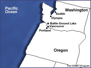
The Paleoclimate of Battle Ground Lake, Washington
The research site is located 30 km north of the Columbia River, in Clark County Washington, near the town of Battle Ground. This description was provided by Dr. Cathy Whitlock.
The lake has been in existence for at least the last 20,000 years and has continuously accumulated sediments through most of that time. Trapped in the sediments are pollen grains from the plants that grew in the general vicinity of the lake at the time the sediments were deposited. By examining the pollen in different layers of sediment from the bottom layer to the top, we can reconstruct the vegetation changes that have occurred in the area during the lake's existence. Because we know something about the climatic conditions that the plants needed to survive, we can use the vegetation data to reconstruct the past climate in the area for the entire 20,000-year period.
Many layers have been identified by paleoclimatologists. For the sake of simplicity, we will combine these into five major layers. The age of each layer has been established by radiocarbon dating and by reference to volcanic ash layers of known age from Mt. St. Helens and from the explosion of Mt. Mazama (now Crater Lake in Oregon).
| Layer | Time Period | Description |
|---|---|---|
| #1 | 4,500 years before present (ybp) - Present | A cooler and moister period than the previous one. The dry-land vegetation is replaced by the extensive closed coniferous forests seen today, with hemlock and western red cedar dominating the areas of forest undisturbed by logging. |
| #2 | 9,500 - 4,500 ybp | The climate continues to warm with mild, moist winters and warm, dry summers predominating. The forests of the previous period (which needed cooler, moister conditions) disappear to be replaced by more drought-adapted mixed oak, Douglas fir, and a dry meadowland community. Today, such vegetation is typical of areas of the Willamette Valley of Oregon that have escaped cultivation. |
| #3 | 11,200 - 9,500 ybp | The warming continues and the first occurrence of "modern," temperate coniferous forest is found in this period as Douglas fir, alder, and grand fir dominate in forests, not unlike those that occur today. The climate is similar to today's climate as well. |
| #4 | 15,000 - 11,200 ybp | Glaciers have begun to recede as the climate starts a warming trend. Although still cold in comparison to the present climate, the warming has progressed enough to allow more extensive forests of lodgepole pine, Engelmann spruce, and grand fir to replace the tundra vegetation in an open woodland setting. Further north in the northern and central Puget Lowland, the glacial recession has opened up many new areas to plant colonization, and lodgepole pine has invaded these new areas. |
| #5 | 20,000 - 15,000 ybp | Glacial maximum, with nearly a vertical mile of ice over the site of Seattle, and the continental glaciers extending south of the present site of Olympia. An alpine glacier from Mt. St. Helens extended down the Lewis River Valley to within 30 km of the lake site. The lake area climate was cold, with a short growing season. The landscape resembled an arctic/alpine tundra, with alpine grasses/sedges, low woody shrubs, and scattered tree islands of cold-tolerant Engelmann spruce and lodgepole pine dominating the meadows. |
Reference: Barnosky, C. W., 1985. Late quaternary vegetation near Battle Ground Lake, southern Puget Trough, Washington. Geological Society of America Bull., 96, 263 - 271.
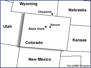
The Paleoclimate of Blackhawk, Colorado
The research site simulated in this activity is the Eiven Jacobson farm outside the town of Blackhawk, Colorado. It is located on the Peak to Peak Highway at an elevation of 9002 feet.
In a valley on the farm, a peat bog developed over the centuries. Through carbon-14 dating of the sediment layer and pollen samples, the paleoclimate of this area of Colorado has been established. The peat bog and soils underneath it have been in existence for eons and have accumulated sediments over time. Trapped in these sediments are pollen grains from a variety of plants that grew in the area at the time the sediments were deposited. By examining the sediments from the bottom to top (oldest to youngest), we can reconstruct the vegetation changes that occurred in the farm's area during the last several thousand years. Because we know something of the climatic conditions that these plants need to survive, we can use the vegetation data to reconstruct the past climate in this area for the last 10,000 years. As climate changes with time, so do the plant communities. Plant communities will migrate up the mountains during the warming periods and fall back down again as the climate cools. The tree line changes in conjunction with this shift, perhaps helping us understand why there are ancient bristlecone pines on Mt. Evans (elevation 14,000+ feet).
| Layer | Time Period | Description |
|---|---|---|
| #1 | 150 Years Before Present (ybp) - Present | As our temperatures warm from the Little Ice Age, the plants change as well, back to those that thrive in warmer climates. Today at approximately 9000 feet, we find ponderosa pines, meadow grasses, wildflowers, and aspens, which are all indicative of the milder climate we are experiencing. |
| #2 | 650 - 150 ybp | The term "Little Ice Age" gives us an idea of a change that began to happen climatically at this time. Gone were the warm days of the Medieval Warming Period and the big chill set in; cooler temperatures were the norm. Once again the Engelmann spruce and limber, lodgepole, and bristlecone pines dotted the landscape. |
| #3 | 1,500 - 650 ybp | This period is termed the "Medieval Warming Period." No longer do the spruces and cold-tolerant plants dominate the landscapes. The vegetation is also shifting with the change in temperatures. Now the landscapes primarily consist of ponderosa pines, Douglas fir, meadow grasses, and wildflowers. |
| #4 | 3,500 - 1,500 ybp | A cooler and moister period succeeds the past warmer climate. The predominant vegetation species are Engelmann spruces, limber, lodgepole, and bristlecone pines, aspen, and wet peat plants, such as sedges, willows, and mosses. At about 2,000 ybp, the peat from the Jacobson's peat bog began to develop and grow in this cooler, wetter climate. |
| #5 | 8,000 - 3,500 ybp | This was a warmer era, with the vegetation dominated by Douglas fir, ponderosa pine, aspen, meadow grasses, and wildflowers, similar to what we see now on the Jacobson farm. These species tend to grow best under temperate, somewhat moist conditions. Forest fires were also quite prevalent during this time. |
| #6 | 10,000 - 8,000 ybp | The period right after the last glacier was a very cold time with gradual warming. The cold temperatures at the end of the Pleistocene period were giving way to the warming trends of the Holocene. The era was characterized by a very short growing season. The landscape resembled an arctic/alpine tundra, with the meadows dominated by alpine grasses, daisies, alpine sage, and sedges. Scatter trees, the cold-tolerant Engelmann spruce, some willows, and aspens began to appear toward the end of this period in scattered tree islands. |
This information was provided by the Science Discovery Program at the University of Colorado - Boulder.
Teaching this Lesson
In this activity, students will examine pictures of pollen grains representing several species that show the structural differences that scientists use for identification. Students will analyze model soil samples with material mixed in to represent pollen grains. They will determine the type and amount of "pollen" in the samples and, using information provided to them, determine the type of vegetation and age of their samples. Then they will make some conclusions about the likely climate at the time the pollen was shed.
You will gather your own 'soil' for the samples and then use one of these data sets to interpret it:
- From a lake in Washington State just south of the glacial limit of the last ice age, reflecting the climatic changes that accompanied the end of the ice age to the present.
- From a peat bog in Colorado, which accumulates pollen in a fashion similar to a lake.
Choose the set that might seem most interesting to your students. The only difference between them is that the Washington data set records 5 distinct climatic layers, with 11 different plant species, whereas the Colorado data set records 6 climatic layers, with 12 distinct plant species.
Modifications for Alternative Learners
This is a complex activity for English Language Limited (ELL) students, in terms of the learning outcomes expected. Pair ELL students up with students who can serve as guides through the activity.