Reducing the Risks
![]() This is Part 3 of Lesson 6 of Project Resilience curriculum.
This is Part 3 of Lesson 6 of Project Resilience curriculum.
Students will use flood risk scenarios from three Louisiana parishes to investigate types of risk reduction projects and understand how community factors impact the selection of the community’s risk reduction projects.
Learning Objectives
- Students will explore the difference types of risk reduction projects.
- Students will understand the factors that communities must consider when selecting risk reduction projects.
Materials
- Projector
- Project Resilience Slide Deck (slides 73-78)
- Risk Reduction Student Sheet (PDF)
Preparation
- Print out copies of the Risk Reduction Student Sheet, one copy per group.
Directions
Learning about different kinds of restoration projects (40 min)
- Review the list of restoration projects within the Coastal Master Plan (Slide 73). Explain that the plan also includes some adaptation projects in addition to protection and restoration projects. What comes to mind when you hear of a risk reduction project?
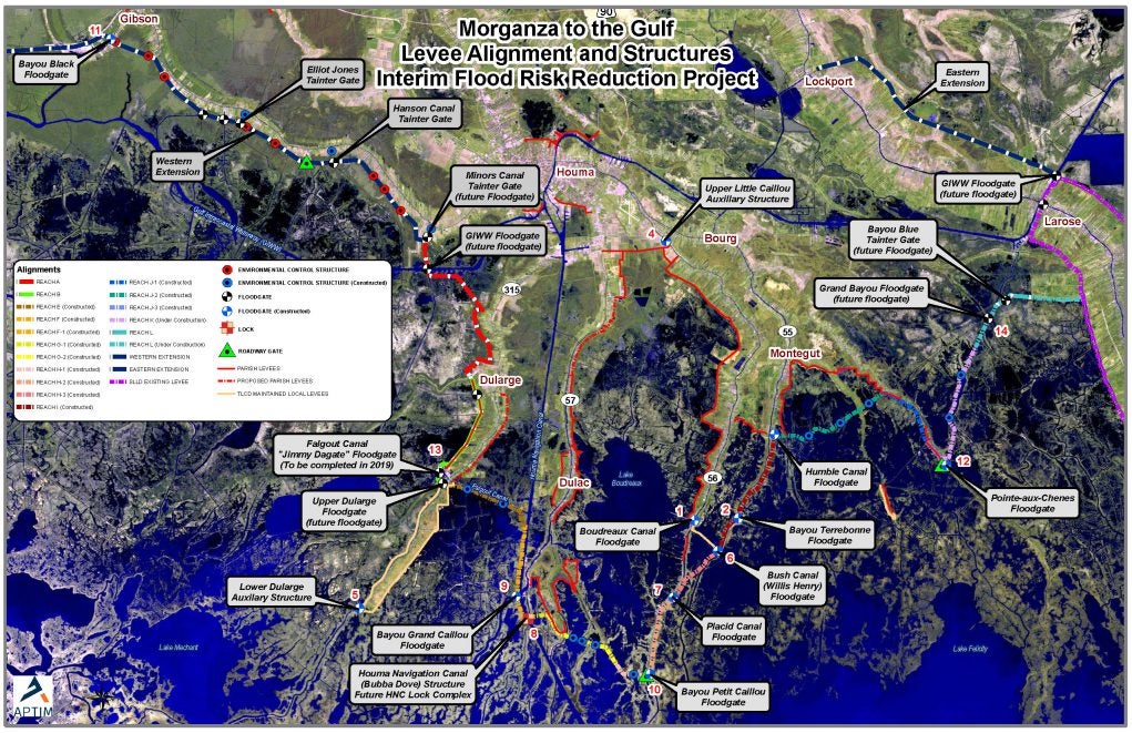
- Introduce the two categories of risk reduction projects: Structural protection and nonstructural protection (Slide 74). What is the difference between the two projects? What are some examples of a structural protection project? Nonstructural protection? Introduce the Morganza to the Gulf levee system as a structural protection project (Slide 75).
- Discuss the examples of nonstructural protection: flood-proofing, elevated houses, voluntary acquisition. Have you seen any elevated houses? Where? Do you know anyone that has moved due to their flood risk increasing? Do you know of anyone who has moved due to rising flood insurance costs?
- If a community's flood risk increases dramatically and they face permanent inundation in the next 50 years, a community resettlement plan may be necessary. What would you need to take into consideration for a community resettlement plan? What factors would influence a nonstructural project?
- Pass out the Risk Reduction Student Sheets and have students divide into pairs. Explain to students that each color represents a different flood depth. Using the color key (with the elevated house), students can see how the flood risk changes throughout the region. Have the students read the parish description and answer the questions for Scenarios 1-3. They should be able to list at least four factors and at least one risk reduction project recommendation for each scenario.
- Discuss as a class what factors each pair has recorded and which projects they recommend (scenario maps are included in Slides 76-78). Ask students: What long term environmental problems may affect these adaptation projects? Would the group's project be successful in the long term?
Revisit Driving Question Board (10 min)
- Have students revisit the class Driving Question Board (DQB). You might consider doing this in small groups and then share out as a whole class. Ask the following questions:
- Are there any questions that we can now answer?
- Do we want to re-arrange any of the questions?
- Are there any connections between topics that we should show on the DQB?
- Would anyone like to add any additional questions?
Assign Journal Prompt #14.
Prompt #14: Many different types of projects are being constructed along the Louisiana coast, including both restoration projects and risk reduction projects. What type of factors will officials need to consider when designing risk reduction projects? What different factors would they need to consider constructing structural protection projects versus nonstructural?
Background
Risk Reduction:
- Structural Protection: reduce flood risk by acting as a physical barrier against storm surge. Examples include:
- Levees
- Floodgates are needed where levees or concrete walls cross a road or railroad or where they intersect waterways.
- Floodwalls are typically located at points along earthen levees that have a high potential for erosion, or insufficient space for the wide slopes of an earthen levee. Floodwalls were specified at junctions with water crossings, railroads, and major roadways (i.e., interstates and state highways).
- Pump stations are needed in enclosed risk reduction systems to allow water that enters a polder to be pumped out. Pumps were included as features of most of our protection measures.
- Nonstructural Protection: elevate and flood-proof buildings, help property owners prepare for flooding, or move out of areas of high flood risk. Examples include:
- Elevation of residential structures is recommended in areas with a projected 100-year flood depth of between 3 and 14 feet so that their lowest floors are higher than projected flood depths.
- Floodproofing of non-residential structures is recommended in areas with projected 100-year flood depths of 3 feet or less, so they can be resistant to flood damage. Floodproofing of a residential building does not affect the flood insurance rating. Frequently asked questions about nonstructural protection.
- Voluntary Acquisition of residential structures is recommended in areas where projected 100-year flood depths make elevation or floodproofing infeasible, and where residential structures would need to be elevated higher than 14 feet.
- Examples:
- Buyouts for Permanent Resident Households (LA SAFE)
- Elevated homes
Morganza to the Gulf Levee System
- The Morganza-to-the-Gulf Hurricane Protection System is a levee, lock, and floodgate system designed to provide 100-year, Category 3 storm surge protection to more than 150,000 people living in coastal Terrebonne and Lafourche Parishes (60 miles southwest of New Orleans) as well as over 1,700 square miles of fresh and saltwater marsh.
- The tentatively selected plan in the PAC report consists of:
- approximately 98-miles of earthen levees ranging from 9 – 15 feet
- 22 floodgates on navigable waterways
- 23 environmental water control structures
- One lock complex consisting of a lock in the Houma Navigation Canal measuring 110-ft wide by 800-ft long, an adjoining floodgate measuring 250 feet wide, and a dam closure
- Nine road gates
- fronting protection for four existing pump stations.
- No Federal funds have been appropriated for construction of the Morganza to the Gulf project; however, the non-Federal sponsor is using state and local funds to construct interim features along the authorized alignment in advance of the Federal project.
- As of December 2017, approximately 45 miles of levees and floodgates along the Morganza to the Gulf alignment from Cut Off to Bayou Dularge are permitted, under construction, or completed. All with only local and state funding.
- $450 million in local and state funds have been invested to date in the Morganza system, and projects totaling $500 million are in the planning phase.
Extensions
Field Trip
- See an example of a resilience field trip to Isle de Jean Charles, Louisiana.
- This field trip included examples of coastal land loss and adaptation projects at both the community and the individual level.
- Research potential field trip locations that would provide an example of resiliency within the community. Depending on the locations, you may be able to include multiple locations in one field trip. At least one field trip location should include a constructed resilience project. If possible, determine two field trip locations. One field trip location without a resilience project and the second location with a resilience project.
- Once you determine the locations, research the individual projects or potential projects for that specific location. Determine why the project was constructed and how it will impact the area into the future. If possible, invite one of the project coordinators to speak with the students during the field trip.
- Develop a field trip schedule. If you have two locations, begin with the resilience project location (with the guest speaker if included) and then visit the second location. Students may have to remain on the bus depending on the project locations. If students cannot walk around the field trip location, include a short stop with available restrooms. Include a lunch stop (such as a park) if you will be returning after the school’s normal lunch hour.
- Set your field trip date. Follow your school’s policy for bus reservations and student permission forms.
- Have students bring paper and pencil on the field trip. Encourage students to write down observations about the field trip locations and their community. Students could also take pictures of the resilience projects or of areas that would benefit from a resilience project.
- Have students think about the following questions:
- What is the history of this area?
- What environmental problems will this community face in the future? (These problems will be very similar to the problems addressed in Lessons 1-3)
- Why did they construct this resilience project? How will it help the community?
- What other locations in the community would benefit from a resilience project?
- How will your school resilience plan tie into the resiliency of the community?
![]()
Credits
This activity was developed for Project Resilience, funded by the Gulf Research Program of the National Academies of Sciences, Engineering, and Medicine.