Make a Tornado
Students explore factors that influence why certain areas in the United States have more tornadoes than others and observe a model to visualize what is happening during a tornado.This lesson is best placed in the learning sequence following learning about the formation of thunderstorms.
Learning Objectives
- Students will use a model to learn about the formation of tornadoes in nature.
- Students will discover that most tornadoes in the United States occur in “Tornado Alley” and why this happens.
- Students will analyze data from maps to make connections between factors that influence tornado formation.
- Students will discuss and revise their thinking with peers in order to reach a consensus.
Materials
- Wooden board (10 in x 12 in)
- Hot glue gun
- 2 (0.01” thick) Vinyl sheets measuring 9 in x 10 in
- Small hand-held battery-powered fan
- Small plastic dish or cup
- Clear plastic plant saucer (7” diameter) *note: you will need to cut a 2” hole in the saucer
- Box cutter knife or sharp scissors to cut the plastic plant saucer
- Water (½ cup)
- Dry Ice
- Gloves (optional: tongs) to handle dry ice
- Dry erase board or chart paper and markers
- Projector & computer
- Make a Tornado slide deck
-
graphic organizer
Preparation
- Review the materials list and gather all supplies.
- Construct the model(s) in advance, through Step 4 below (recommended), or have students construct models in class.
- Print a copy of the Discussion Diamond graphic organizer for each group and a set of Student Weather Maps (four different maps) for each per group. *Note: color prints of the Student Weather Maps are ideal for this activity.
- Review background information about tornado formation.
*Note: can be done as a whole class demonstration with just one model, or if you have enough materials you could construct multiple models to be used in small groups.
Directions
Engage: What do we know about tornadoes? (10 min)
-
Think-Puzzle-Explore: On the board or chart paper, create a three-column chart with "Think, Puzzle, Explore" at the top of the columns. Lead a discussion with students “What do we think we know about tornadoes already?” “What questions do we have about tornadoes?” and finally, “What would you like to learn or explore about tornadoes?” Record all student comments. (Hopefully there are student wonderings around “how tornadoes work” and “where tornadoes occur”; draw attention to these topics if so, as they will be the focus of our lesson.)
-
Introduce the tornado model by offering that perhaps some of the things we are puzzled about with regards to tornadoes could be explored using a model.
Explore: Observing a Tornado Model (15-30 min)
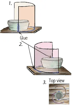
Build the Tornado Model
*Note: you might prefer to build the model in advance, through Step 4
-
Glue the plastic dish/cup in the center of the piece of wood.
-
Use hot glue to attach one of the vinyl sheets along the side of the plastic dish. Bend the vinyl sheet to make a half-circle around but not touching the cup. Glue the vinyl sheet to the board.
-
Use hot glue to attach the second vinyl sheet along the opposite side of the plastic dish. Bend the vinyl sheet to make a half-circle (just as you did in Step 2) around but not touching the cup. Check that your clear plastic plant saucer will fit over the top of your vinyl sheets; adjust size if needed to get a good fit. Glue the second vinyl sheet to the board. Important: the two vinyl sheets must overlap but NOT touch.
-
Using the box cutter knife, cut a hole in the center of your clear plastic plant saucer. The hole should be approximately 2 inches in diameter, or big enough to fit your handheld fan. For safety, box cutter should be used by an adult only!
*Note: if constructing your model in advance, stop at this step; the following steps should be completed just before you are ready to observe your tornado!
See diagram below:
5. Pour about half a cup of water into the plastic dish (attached to the piece of wood).
6. Using gloves and tongs (optional), place a few pieces of dry ice into the dish of water. For safety, this should be done by an adult only!
7. Quickly place the plant saucer upside down on the top of the model.
8. Turn on the fan and place it, facing up with air blowing out, in the hole at the top of the saucer to draw the air up. See diagram below.
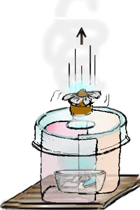
9. Observe the funnel cloud form!
10. Add more dry ice as needed
Explain: Understanding the Tornado Model (15 min)
-
Think-Pair-Share: Ask students to think on their own and then share with a partner their observations and ideas about how the tornado is forming in the model. They could draw and label a diagram in science notebooks if desired.
-
Project the diagram of a tornado (shown below) from the Make a Tornado slide deck and hold a class discussion to compare your tornado model to what happens in an actual tornado:
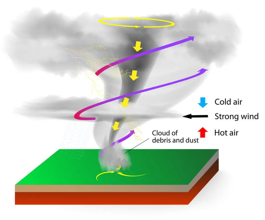
Shutterstock
-
What is coming off of the dry ice? (water vapor; as it warms it turns from a solid to a gas… this causes the air to cool) Where do we see this in the diagram?
-
What is the fan doing? (creating the vortex by pulling air in through the bottom and out the top of the model) Where do we see this in the diagram?
-
How does the cloud form in our model? (clouds form as water vapor rises and cools in the air) Where do we see this in the diagram?
-
What do you think the different arrows represent in the diagram? (Up arrows= updraft created by the warm air rising. Down arrows= funnel cloud touches the ground due to rain/hail falling towards the ground)
-
How is our model different from what we see in the diagram? What is missing from our model? (No strong wind to create wind shear, which is what forms the vortex in a funnel cloud. In our model the spinning fan blades caused the vortex to form.)
-
Explore: What is Tornado Alley?(20 min)
-
Present the idea that scientists are still not certain exactly why a tornado forms in one storm and not in another. But we do know that there are more tornadoes in the US than in any other country in the world, and that they occur in some places way more than others.
-
Activity: Discussion Diamond with Student Weather Maps
-
Break students into groups of four. Pass out to each group a copy of the Discussion Diamond Student Page and one copy of each of the (4) Student Weather Maps (each student in the group should have a different weather map to become the “expert” of).
-
Write the guiding question on the board: Why do some areas in the United States have more tornadoes than others?
-
Using the Discussion Diamond: Give students 5 minutes to consider the information on their weather map. Ask them to look for patterns and do a See-Think-Wonder with their map (What do I see? What do I think it means? What do I wonder about?). Each student writes their thoughts about their map in one of the corners on the Discussion Diamond sheet. The middle should remain blank for now.
-
After 5 minutes, students take turns explaining their See-Think-Wonders to each other, using their maps and the notes they wrote in their corner of the Discussion Diamond.
-
Once each group member has shared, they work together to reach consensus about how the information on the different maps fits together. Students write a statement, as a group, in the middle of the Discussion Diamond that reflects their thinking.
-
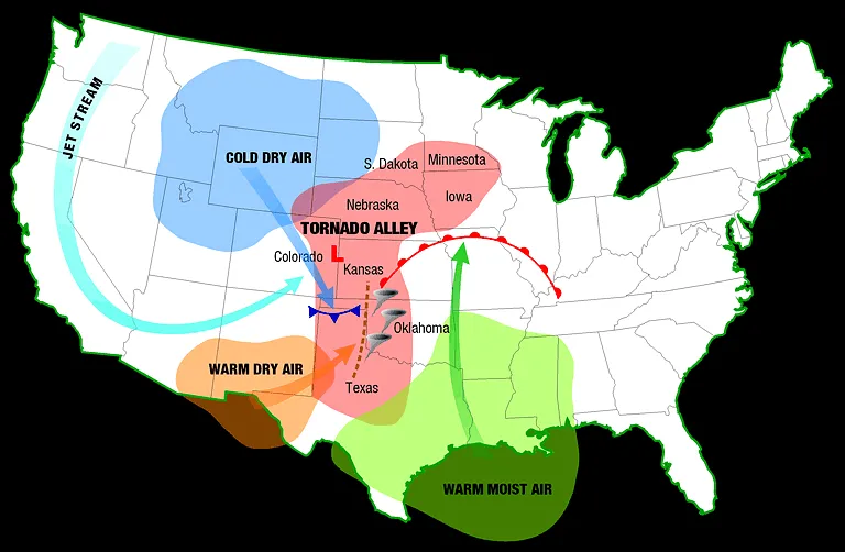
Project the Tornado Alley diagram (shown below) from the Make a Tornado slide deck and hold a class discussion.
- Say: The area where there are the most tornadoes in the US is sometimes referred to as Tornado Alley.
- Ask: Where do you see similarities on your maps with this one? What other questions do you have?
- Explain Tornado Alley with as much detail as you feel is necessary for your students.
-
Elaborate: Studying Tornadoes (5 min)
-
Remind students that even though we recognize conditions that are favorable for a tornado to form, we still cannot accurately predict every time a tornado will actually happen. Some of this is because tornados are challenging to study up close. Weather scientists are coming up with better ways to study tornadoes and to help warn people that they are coming sooner as a means to improve safety.
-
Find and share images of Doppler on Wheels (DOW) vehicles that are specially designed to study severe weather & tornadoes (check the Center for Severe Weather Research website for good images).
Extensions
-
Study the Fujita scale for measuring tornado damage, make a chart that explains the characteristics of different Fujita rankings and provide an example of a real tornado with each ranking.
-
Learn about tornado warning systems and safety during a tornado; relate this to the tornado risk in your local area and create a Public Service Announcement (flyer, pamphlet, video, etc) to inform your community of what to expect if a tornado occurs.
-
Research some of the most historic and/or most recent tornadoes.
-
Explore the relationship between potential & kinetic energy in a tornado by creating a water vortex in a 2 liter soda bottle with this Windstorm activity from Teach Engineering.
Assessment
Connect-Extend-Challenge: have students write down connections that they made during the activities today to what they already knew about tornadoes. They should also write down any new ideas they got today that extend their understanding about tornadoes (what do they understand now that they didn’t before?), and finally what is still challenging for them to get their mind around (what questions do they still have? What are they still puzzled about?)
Background
What’s happening with the Tornado Model?
The whirling fan as the top creates a spinning “updraft” or vortex. This pulls air in at the bottom of the container and out at the top of the plant saucer. Dry ice is made of frozen carbon dioxide. It is very cold. As it warms. It turns from a solid (ice) into a gas (this is called sublimation). It cools the air above it, causing a little cloud of water vapor to condense from the air. The little cloud enters the updraft, allowing us to see the vortex which resembles a small funnel cloud.
How does this relate to weather?
In a natural environment, how would the column of air begin to rotate without a huge fan placed on top of the thunderhead? This is not completely understood by scientists, but one way the rotation appears to happen is when winds at two different altitudes blow at different speeds creating wind shear. For example, a wind at 1000 feet above the surface might blow at 5 miles per hour (mph). Wind at 5000 feet might blow at 25 mph. This causes a horizontal rotating column of air. If this column gets caught in a supercell updraft, the updraft tightens the spin, and it speeds up. This is much like a skater's spin speeds up, (much like an ice-skater spins faster when the arms are pulled in close to the body). A funnel cloud is created. The rain and hail in the thunderstorm cause the funnel to touch down. This creates a tornado.
How do Tornadoes Form?
Tornadoes only form when a thunderstorm has a particular combination of winds. Air rising in thunderstorms can begin to spin when it's affected by winds blowing it in different directions. It starts to rise and is pushed to the side by wind. It rises a bit more and is jostled again by wind moving in another direction. Winds moving in different speeds and directions at different altitudes cause the rising air to start spinning.

A tornado can form in a thunderstorm where the rotating air of an updraft (shown in purple) meets the rotating air of a downdraft (shown in aqua), which has turned upward.
Paul Markowski, Penn State University
Air that spins as it rises is typical in supercells, the strongest type of thunderstorm, but not all spinning air creates a tornado.
For a tornado to form, there also needs to be spinning air near the ground. This happens when air in the storm sinks to the ground and spreads out across the land in gusts. Gusts of warmer air rise as they blow. Gusts of cooler air sink as they blow across the land. If there are enough rising and sinking gusts, the air near the ground starts spinning.
The spinning air near the ground speeds up as it’s drawn inward toward its axis of rotation. This happens in the same way that figure skaters spin faster when their arms are drawn in rather than when their arms are outstretched. This is called conservation of angular momentum.
The rotating air moves horizontally across the land and can be tilted vertically by the force of the rising, rotating air. That allows a tornado to form.
Information about Tornado Alley
In the spring and summer the middle of the United States it is quite hot which allows the air to hold a large amount of water. There are always warm, moist air masses moving up from the Gulf of Mexico; there is always cool, dry air masses moving at high altitudes from the North and from the West (Rocky Mountains). The Jet Stream helps to keep moving the air masses across the land. When you have a storm front (where differing air masses collide) the conditions are perfect for these big storms, or supercells, to form. All these conditions collide here in a way that results in very powerful storms and the highest chances of destructive tornadoes.
The term Tornado Alley is a nickname that has been given to the area of the United States where the incidences of significant tornadoes appear to be most prevalent, in other words where the greatest danger from tornadoes exists. Tornadoes can and do happen in areas outside of Tornado Alley, but they are most likely to be less dangerous and result in less damage than those that occur within the Tornado Alley region. There are also many tornadoes in Florida, but they are often smaller and less dangerous.
Weather Maps Explained
- Average Number of Tornadoes Per Year (Map 1): More tornadoes happen during the spring & summer because these are the times with the warmest temperatures. We also see that there are many more tornadoes in the middle-eastern states than in the western United States.
- Tornadoes by Season (Map 2): Most tornadoes happen in the “Tornado Alley '' area of the United States; Oklahoma and Texas have more tornadoes than any other states. There are also many tornadoes in Florida, but these are often not as destructive as tornadoes in the midwest.
- Average Number of Thunderstorm Days per Year (Map 3): The Continental polar (cool/dry) air masses collide with the Maritime tropical (warm/moist) air masses in the center of the United States, right where Tornado Alley! The movement of these air masses creates consistent conditions for storm fronts, where differing air masses collide. Also apparent from this map is why the coastal areas in the United States have so many storms; cooler air from the north meets warmer air from the tropics, combined with all the moisture air over the oceans is carrying.
- Air Masses (Map 4): There are more thunderstorm days in the southern states due to the abundance of warm, moist air. We can see a correlation in Florida between the number of thunderstorms and frequency of tornadoes. However the map of most thunderstorms does not directly align with the map of highest occurrence of tornadoes for the rest of the country. This is because the presence of cool air at high altitudes coming off the Rocky Mountains and from the north, which creates consistent conditions for destructive tornadoes, is missing from the southern states.