Fast Fires: A Compelling Way to Understand Wildfires
Fires are commonly characterized by the total number of acres burned rather than the rate in which they spread. Studying the speed of a fire adds an important dimension that can aid in managing and preventing fires in the future. Fast fires are a result of changing conditions in the environment and increased human development in wildland areas. Put together, these factors increase the chance of extremes in property damage and threat of fatalities. Since 2016, researchers have noticed that the severity and number of fast fires has increased over time, suggesting a foreshadowing of what is to come in the years ahead (Science, 2024).
What is a fast fire?
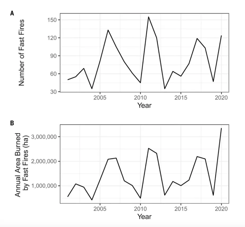
Exposure to fast fires (>1620 ha/day) from 2001 to 2020.
(A) Number of fast fires per year. (B) Annual area affected by fast fires.
Science, AAAS, 2024
Fast fires burn at a rate of at least 16 square kilometers or 6 square miles in a day. Up until now, only a small number of wildfires have burned this quickly, and they can cause a lot of damage. To define fast fires with greater precision, researchers compiled a list of the fastest spreading fires from 2001-2020 across the contiguous U.S. This was determined by the number of days the fire lasted, the number of buildings and properties exposed, fire size, and fire growth rate (acres burned per day). The results showed that while fast fires represent only 2.7% of total fire events, they are highly destructive. According to the study, 89% of total structures damaged or destroyed occurred during fast fire events.
The Wildland-Urban Interface: More Development, More Risk of Wildfire
In compiling the list, one significant factor stood out: 16 out of 20 of the fastest-growing, destructive fires occurred in grassland areas. Often, these fires are associated with strong gusts of wind that spread the fire quickly. Grasslands, especially areas that experience wet seasons where vegetation grows, followed by severe drought seasons that dry out vegetation, result in a highly combustible fuel source. As housing developments encroach onto formerly open wildland vegetation areas like grasslands or forest, homes become an additional fuel source for wildfire to spread rapidly.
The zone where development meets up with open wildland vegetation is known as the Wildland-Urban Interface (WUI). In periods of high wind, wildfires in the WUI can be exponentially destructive, as was the case for the 2021 Marshall Fire in Colorado and the 2025 Palisades and Eaton fires in California where property damage reached unprecedented levels. As human development increases in WUI areas, the likelihood of wildfires also increases.
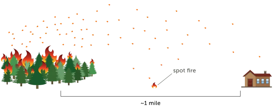
Embers can travel a mile or more, igniting vulnerable homes or nearby landscaping. (Headwaters Economics)
Credit: Headwaters Economics
One of the primary ways that homes in the WUI catch on fire is due to embers lofting up in the air. These embers, also known as firebrands, can travel great distances, landing and igniting fuel sources that in turn catch homes on fire. Clearing out combustible vegetative material, such as piles of pine needles, leaves in gutters or on decks, and stacks of firewood close to the house, particularly around the perimeter (0 to 5 feet from the house), is essential. Additional preventative measures such as creating a defensible space around a home by mowing tall grass and weeds as well as the use of non-combustible roof materials can also make a big difference when it really matters.