El Niño-Southern Oscillation
Floods and mudslides in Ecuador, droughts and wildfires in Australia, and extreme California rainstorms – could all of these events be triggered by the same thing? Yes, they can - El Niño-Southern Oscillation (ENSO) might be the culprit! El Niño refers to changes in sea surface temperature and Southern Oscillation refers to air pressure changes in the atmosphere above the equatorial Pacific Ocean - together they are referred to as the El Niño-Southern Oscillation (ENSO). When changes in both the ocean and the atmosphere take place at the same time, extreme weather events often result.
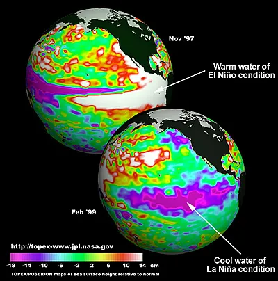
The red and white color of the eastern tropical Pacific in the upper image (from Nov. 1997) indicates a higher than normal ocean level due to the piling up of warm ocean water during El Niño. The lower image (Feb 1999) shows the ocean level during La Niña when there is cool water from upwelling in the eastern tropical Pacific. Data is from TOPEX/Poseidon and Jason-1 and shows the height of the ocean surface.
NASA JPL
ENSO causes a disruption to global atmospheric circulation, which results in shifting temperature and precipitation patterns. Normally, trade winds move water at the ocean surface from the eastern tropical Pacific towards the western Pacific. This creates an upwelling of cold nutrient-rich water off the coast of Peru and Chile, which supports a high diversity of marine life. The western Pacific is normally in a low pressure system and has wet weather. The eastern Pacific is normally in a high pressure system which creates dry weather. But every 3 to 7 years, the atmosphere and ocean change during El Niño and La Niña events – the two extremes of ENSO.
El Niño
El Niño is characterized by a warming of sea surface temperatures. During El Niño, air pressure rises in the western Pacific and falls in the central and eastern Pacific, causing the air pressure to even out between the Pacific regions. Without a strong pressure gradient, the trade winds weaken. Without the trade winds, there is less upwelling near the coast of South America and the warm, nutrient-poor water of the western Pacific spreads into the eastern tropical Pacific. The warm nutrient-poor waters can't support as much marine life as the cool nutrient-rich waters can. Warm water evaporates faster than cool water, leading to more water vapor in the air which can cause high humidity and storms in areas that are usually dry.
La Niña
During La Niña, the cold phase of ENSO, sea surface temperatures drop. The trade winds grow stronger across the Pacific because the low pressure over the western Pacific strengthens, as does the high pressure over the central and eastern Pacific. This causes more upwelling of ocean water off the coast of Peru and Chile, making the surface water of the eastern tropical Pacific unusually cold. La Niña brings an increase of precipitation over the central tropical Pacific, and drier weather over Indonesia.
ENSO Events Affect Weather and Climate
Both El Niño and La Niña events can have far-reaching effects on the weather and climate. Intense rainstorms and flooding, extreme droughts, the strength of the Atlantic hurricane season, and winter storms in many areas of the world are affected by ENSO events. When an ENSO event occurs, climatologists often predict an increase in severe weather over the next several seasons. ENSO may also have an impact on the North Atlantic Oscillation, which can result in unusual weather in the Northern Hemisphere. These impacts are called teleconnections because changes in one area often affect other areas.