Parts of the Cryosphere
Frozen water is found in many different places on Earth. Snow blankets the ground at mid and high latitudes during winter. Sea ice and icebergs float in the chilly waters of polar oceans. Ice shelves fringe land in Earth’s polar regions. Glaciers and larger ice sheets move slowly over land in polar regions. Glaciers are also found on high mountaintops around the world. The soils of polar regions, called permafrost, are filled with frozen water. Together, these different types of frozen water are known as the Earth’s cryosphere. Approximately three-quarters of the world’s fresh water is frozen in the cryosphere.
Some parts of the cryosphere, such as snow and the ice on ponds and lakes in mid-latitude locations, are only around during winter months. Other parts of the cryosphere, such as glaciers and ice sheets, stay frozen year-round and, in fact, can stay that way for tens or even hundreds of thousands of years. Some of the ice in the ice sheet that covers most of the continent of Antarctica has been there for nearly a million years.
The cryosphere is tied to the other parts of the Earth system. Here are some examples:
- Because snow and ice are light in color, they reflect more of the Sun’s energy back into space. When snow and ice melt, darker ocean and land are exposed. The darker colors absorb and then radiate more of the Sun’s energy, warming the atmosphere.
- When ice and snow melt, the water becomes part of the hydrosphere. For example, in the state of Washington in the western United States, melting snow and glaciers during summer provides 470 billion gallons of water each summer. The amount of snow and ice that melts each summer is increasing because of global warming.
- Many different living organisms within the biosphere rely on parts of the cryosphere for water and habitat. Polar bears roam across Arctic sea ice as they hunt for seals. Arctic cod take shelter in areas underneath the sea ice. Some penguins rely on the ice during their breeding season. Snow and ice that melt seasonally provide the freshwater that many different plants and animals need to survive.
- Glaciers and ice sheets shape the land's surface. They erode the rocks of the geosphere as the ice moves slowly across the land and then the eroded sediments are deposited in other places. In the tundra ecosystem, soils stiff with ice, called permafrost, sequester greenhouse gases from the atmosphere.
Glaciers

Matanuska Glacier, Alaska, U.S.
Nicole Gordon/UCAR
For a glacier to develop, the amount of snow that falls must be more than the amount of snow that melts each year. This means that glaciers are only found in places where a large amount of snow falls each year and where it is so cold year-round that at least some of the snow does not melt. Cold climates where glaciers are found exist both in Earth’s polar regions and in high-altitude locations at all latitudes.
- Continental glaciers, also called ice sheets, cover large amounts of land in the Earth’s polar regions. The largest ice sheets are located in Antarctica. In the Arctic region, an ice sheet covers Greenland and there is an ice sheet in Iceland. During the most recent ice age (approximately 15,000 years ago) a large continental glacier covered much of the northern part of North America. It is long gone, but it left behind a record of where it traveled in the rocks, sediments, and the shape of the land.
- Alpine glaciers are found in high mountain valleys worldwide. Alpine glaciers are responsible for carving mountains into distinctive shapes, leaving pointed ridges between glaciers, u-shaped valleys where the glacier moved through, and hills of rock debris called moraines that were pushed by the glacier. Today, because of rapid global warming, alpine glaciers that are at tropical and mid-latitudes are melting very quickly.
Snow that falls on a glacier may eventually become part of the glacial ice. The snowflakes become buried under more and more snow, eventually changing their shape because of the pressure from the layers of snow above and becoming part of the massive ice. Over time the ice crystals become so closely packed that the tiny pockets of air between them are squeezed out and the ice changes color from white to blue.
Glaciers are not just giant ice cubes. All that ice can be a powerful force. Glaciers move over time, scraping rock from the Earth’s surface, bulldozing boulders, gravel, and sand into hills, and sending ice out over the ocean in massive ice shelves. Under the pressure of its own weight, glacial ice flows downhill over time. If you were to touch a glacier’s ice, it would feel solid and cold, just like ice usually feels, but over a long time it flows like honey. Glaciers also move downhill by sliding at their base, a process called basal slip. The pressure on the ice that is at the bottom of a glacier causes some of that ice to melt, producing a slippery little layer for the rest of the ice to slide upon.
Ice Shelves
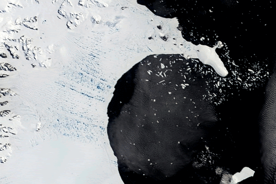
Larson B Ice Shelf (Antarctica) breaking apart in 2002. The collapse of the ice shelf was captured in this series of images from the Moderate Resolution Imaging Spectroradiometer (MODIS) on NASA’s Terra satellite.
NASA
An ice shelf is a part of an ice sheet that extends from land out over the ocean. The ice is tethered to the land by the attached glacier or ice sheet and it is floating in the ocean water at its outer reaches.
There are ice shelves in both the north and south polar regions. In the north, ice shelves can be found attached to the edges of Ellesmere Island, Canada, and attached to Greenland. Ice shelves in the south polar region are found along almost half of the coastline of Antarctica. The largest ice shelf in Antarctica is the Ross Ice Shelf, which is approximately the size of France.
Just like the glacial ice it is connected to, the ice in an ice shelf flows over time. As the ice flows and extends further offshore, large pieces of ice break off of the end of the ice shelf into the ocean during the summer. This process is called calving. The large chunks of ice that are calved off into the ocean are called icebergs. Antarctic ice shelves can calve icebergs that are over 80 kilometers (50 miles) long. This process of icebergs calving into the ocean is natural; however, more calving is happening today because of global warming.
Ice shelves act somewhat like bookends, confining a glacier or ice cap to the land. Global warming has been causing those bookends to melt. There is concern that if some of the world’s larger ice shelves were to break off into the ocean at the point where they connect to the land (called the grounding line), there would be nothing left to hold the glaciers and ice sheets on the land. The formation of icebergs from ice shelves does not cause the sea level to change because both the ice shelf and the iceberg that calves off of it are floating in the water. However, after an ice shelf breaks apart, the glacier that it had supported moves faster toward the sea, its front calving rapidly into the ocean, and sea level rises.
In February 2002, an Antarctic ice shelf called Larson B collapsed into the ocean. A few years before, the nearby Larson A Ice Shelf collapsed. Scientists have found that the ice sheet that had been supported by these ice shelves is now moving eight times faster than it was before the supporting ice shelves collapsed. If all of the ice shelves that surround the West Antarctic Ice Sheet collapsed and the ice sheet moved into the ocean, global sea level would rise approximately 8 meters (26 feet). Thirteen of the world's 20 largest cities are within a few meters of sea level today. An increase in sea level of this magnitude would flood many of them.
Icebergs
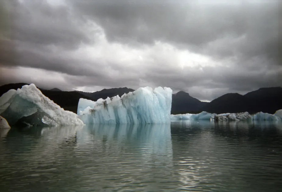
Icebergs in Columbia Bay, Alaska.
Zhenya Gallon/UCAR
Icebergs are large pieces of ice floating in the ocean that have broken off of ice shelves or glaciers in Earth's polar regions. Approximately 90% of an iceberg's mass is below the surface of the seawater. Because ice is less dense than water, a small portion of the iceberg stays above the seawater.
They can be huge — the largest ones are known as ice islands and can be as much as 80 kilometers (50 miles) across. The tallest known iceberg had 168 meters (184 yards) of ice sticking out above the water. Since the part above the water is only 10% of its total size, imagine how much ice a large iceberg has underwater. As they travel from the polar areas where they formed into warmer waters, the ice melts, and icebergs become smaller.
In 1912, a brand-new ship called the RMS Titanic collided with an iceberg in the North Atlantic and sunk on its first voyage. Only about a quarter of the passengers and crew who were on board the Titanic survived. After this huge disaster, the International Ice Patrol was formed to track icebergs in the North Atlantic, ensuring that other ships did not meet a similar fate. The Patrol first monitored icebergs from ships. Later, in the 1930s, airplanes were used to keep track of icebergs. Today, icebergs can be tracked using satellites. In an average year, nearly 500 icebergs pass through the shipping routes in the North Atlantic Ocean. The Patrol warns sailors when the danger of icebergs is high.
Sea Ice
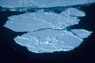
Sea ice in the Beaufort Sea.
NASA
Sea ice is frozen seawater. It can be several meters thick and it moves over time. Although the salts in the seawater do not freeze, pockets of concentrated salty water become trapped in the sea ice when it first forms. The pockets of salty water can work their way out of the sea ice over a few years. During the summer months much of the sea ice melts and during the winter months it forms again. Some sea ice stays around all year long.
The Arctic Ocean has a large amount of sea ice floating on its surface, especially in winter. Sea ice is very important for the people and animals that live in the Arctic region. Animals like polar bears live on the sea ice and find their food in the surrounding and underlying ocean. Marine life exists under the Arctic sea ice too. Over the past few decades, more and more of the sea ice has been melting in the summer as Earth’s climate warms. Scientists predict that with continued rates of global warming there will be no sea ice in the Arctic in the summer months by the end of the 21st century. Ice thickness has also been decreasing. The changes in sea ice are affecting life in the Arctic and causing populations of polar bears to decline.
In the south polar region, there is evidence that sea ice is important for the breeding cycle of certain penguin species. Emperor penguins breed on sea ice. One of the most northerly colonies of Emperor penguins, the one where the documentary “March of the Penguins” was filmed, has declined over the past few decades, probably because of warming temperatures, which cause the sea ice to melt and break apart earlier in the spring, before the chicks are ready to fledge. Melting sea ice might have some benefit to Adelie penguins. Adelie penguins build nests made of pebbles on land. In search of food, they travel over sea ice that is attached to the shore, called fast ice, to get to the ocean, and then bring seafood back to their hungry chicks on land. With less sea ice, the journey to the ocean to find food becomes shorter. However, Adelie penguins are adapted to cold conditions. The benefit of a shorter trip to the ocean is overshadowed by the harm of warmer temperatures. In the northern part of the Antarctic Peninsula, the warmest part of Earth’s coldest continent, the Adelie penguin colony is declining rapidly. In this area sea ice used to be common, but now is absent even in winter. The penguin nests made of rocks on the Antarctic Peninsula have been abandoned. The warming climate has restricted the Adelie penguins to colder areas further south.
Snow
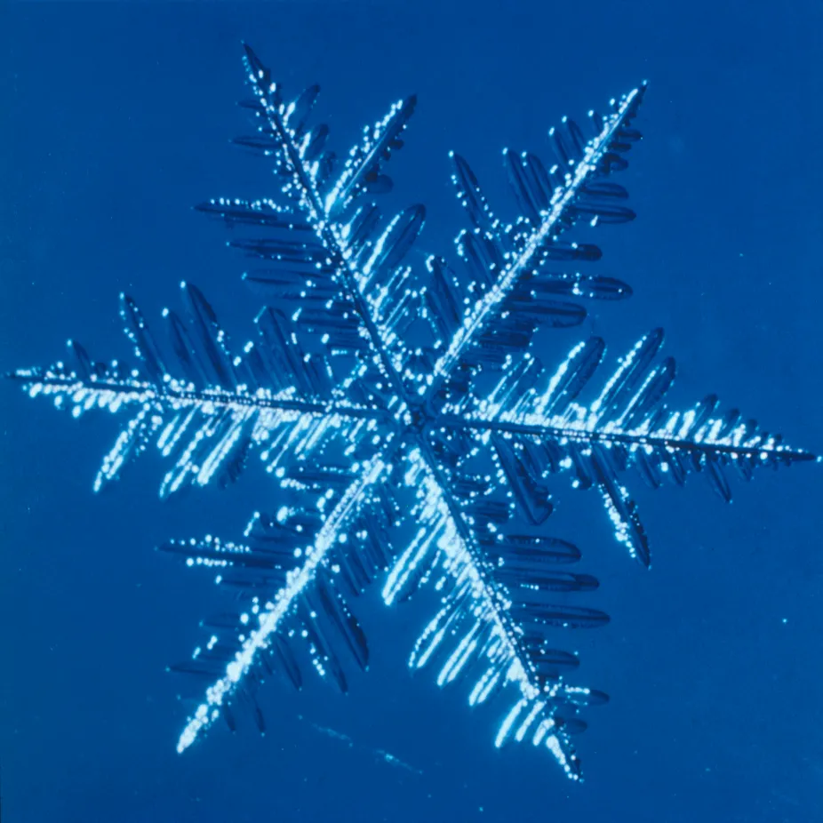
Snowflake
UCAR
Snow is a type of precipitation in which water falls as ice crystals, or combinations of many ice crystals, called snowflakes. Snowflakes form in clouds where the temperature is below freezing (0ºC or 32ºF). The ice crystals form around tiny bits of dirt that have been carried up into the atmosphere by the wind. As the snow crystals grow, they become heavier and fall toward Earth.
Each snowflake can be made of as many as 200 ice crystals. Many snowflakes are symmetrical hexagonal (six-sided) shapes because water molecules often organize with this type of symmetry as they freeze. If they spin like tops as they fall to the ground, they may be perfectly symmetrical. Other types of snowflakes end up lopsided. Different types of snowflakes form in different conditions. Temperature determines if the crystals become a flat plate, a long column, or a prism shape.
On average, 10 inches (25 cm) of snow melt down to about an inch (2.5 cm) of water; however, not all snow is the same. Some places receive very heavy snow. For instance, only 5.5 inches (14 cm) of January snow on Mount Washington, New Hampshire, melt down to an inch of water. In contrast, over 15 inches (38 cm) of January snow at Crested Butte, Colorado, melt down to an inch of water.
There are areas on Earth where snow covers the land surface year-round. These areas are often known as snowfields and are found both at high latitudes, where snow is common and temperatures stay cold year-round, and on mountaintops, where the high altitude causes temperatures to be cold year-round. The extent of the snow cover can change with the seasons — if more snow was added during winter and some of it melted away during summer. Recently, the snow cover on some mountaintops, especially mountains at low latitudes, has been shrinking because the Earth is getting warmer
Permafrost
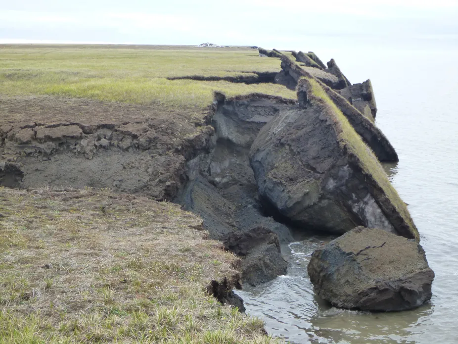
Thawing permafrost causes large blacks of tundra to slump into the Arctic Ocean.
USGS
When the ground under your feet is frozen, interesting things can happen. The land may be covered with circles, polygons, or stripes, called patterned ground, which form as the land freezes. Trees may be few and far between, their roots unable to penetrate the solid ground, leaving the land to only the short tundra plants or no plants at all. Unique hills called pingos, made mostly of underground ice, may dot the landscape, growing larger over time if more ice is added to their core. Or big blocks of land that were once flat may be thrust upward like detached puzzle pieces in areas called blockfields.
That frozen ground is called permafrost. Permafrost can have different characteristics and be found in different forms. It can contain organic-rich soil or be sandy and rocky. It can even be solid rock. It may contain frozen water or be relatively dry. But all permafrost has one important characteristic in common. It is frozen. Permafrost is ground that is below the freezing point of water (0°C or 32°F) for two or more years. Permafrost is found at high latitudes like the Arctic and Antarctic. It is also common at high altitudes — like mountainous areas — wherever the climate is cold. Today about 20% of the land surface is frozen permafrost. Permafrost is considered part of the cryosphere because it is frozen. However, it is also often considered part of the geosphere because it contains rocks and soils.
The top surface of permafrost — called the active layer — usually thaws and refreezes with the seasons. The active layer may only be half a meter (1.6 feet) thick, or it may be as much at four meters (13 feet) thick. Plants can survive if there is an active layer because their roots can penetrate the softened soil and they can find the water they need to survive.
In some areas of the world, permafrost extends very far underground. Under Barrow, Alaska, US, there are 440 meters (481 yards) of permafrost, and in areas of Siberia, Russia, the permafrost is about a kilometer and a half (almost a mile) thick. It took a long time for the ground to freeze to such depths. Shallower permafrost can form relatively quickly; the first hundred meters of ground can freeze in only several hundred years. But it took a much longer time, tens or even hundreds of thousands of years, for ground to freeze to depths of several hundred meters. For example, in a mere 350 years of cold climate, the ground can freeze to about 80 meters (87 yards) of depth, but it takes ten times as long to freeze to about 220 meters (241 yards) of depth. Scientists estimate that it took more than half a million years for the deep permafrost underlying Barrow, Alaska to form. Compared to the long time it took to form, permafrost has been thawing very quickly in recent years due to climate change.