Why Polar Air Keeps Breaking out of the Arctic
Every once in a while, cold Arctic air comes to visit the mid-latitudes. The polar jet stream, which marks the boundary between cold polar air and warmer mid-latitude air, can dip south from its usual perch circling the Arctic and bring freezing cold temperatures. But what is the polar jet stream? It is easy to confuse the polar jet stream with the term “polar vortex,” but they are not the same thing. The polar vortex is a band of strong westerly winds located 16-50 kilometers (10-30 miles) above Earth’s surface in the stratosphere. The polar jet stream occurs in the troposphere at altitudes of 8-14 km (5-9 miles). The stratospheric polar vortex and the tropospheric polar jet stream can interact, but the polar jet stream also varies in association with weather events and large-scale atmospheric circulations.

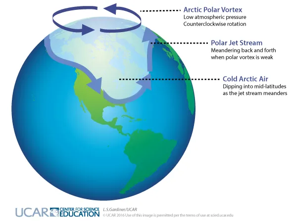
Dark purple arrows indicate the counterclockwise direction of rotation of the polar vortex in the Arctic. The light purple indicates the location of the polar jet stream during a time when meanders form and the cold, Arctic air (white) dips down to the mid-latitudes.
L.S. Gardiner/UCAR
Meanders in the Polar Jet Stream Can Bring Cold Arctic Air South
The polar jet stream is the culprit affecting mid-latitude winter weather. A complex combination of factors sets up these interactions between cold Arctic air and the mid-latitudes. While the polar jet stream tends to mark the boundary between warmer air at lower latitudes and the colder air that often remains contained over the Arctic, the polar jet stream can sometimes develop a more “wavy” or meandering pattern. The meandering causes the large mass of cold air situated over the Arctic to wobble, and, like a toupee that goes askew, cold polar air can slip southward to affect locations in the United States, Europe, and Asia. When the polar jet stream meanders southward across the United States, the cold polar air can push as far south as Texas and the Gulf Coast.

When the polar jet stream develops a more wavy or meandering pattern, cold Arctic air can spill southward to mid-latitudes.
NOAA
A Warming Arctic Complicates This Pattern
The pattern is further complicated by the overall warming of the Arctic, which is occurring at a faster rate than for other areas of the planet. This rapid warming has already been linked to sea ice losses in the Arctic, and scientists are exploring the effects of these changes across other parts of the planet.
The effects of Arctic warming and sea ice loss on the polar jet stream aren’t fully understood, but it’s possible that more frequent visits of polar air to mid-latitudes could occur as a result of these changes. Mid-latitude extreme cold events will continue to happen because of natural variability in the climate system. It is currently uncertain from the observational record whether these meanderings of the jet stream are becoming more or less frequent, and there is an active debate within the scientific community on this topic. As the outbreaks of cold Arctic air to mid-latitudes happen, the overall warming in the climate system means that the temperature swings felt at mid-latitudes can be quite large. Temperatures can be warmer than normal for the season but quickly drop by 16°C (30°F) or more as Arctic air moves south.
Learn More: